Sixteen miles of open water surfski adventure
paddling off Key West.
.
.
If you’ve been following this site you might have noticed
my fascination with offshore ocean paddling
and local lighthouses.
.
.
This story combines open water paddling,
snorkeling and photography with interesting bits of
South Florida nautical history!
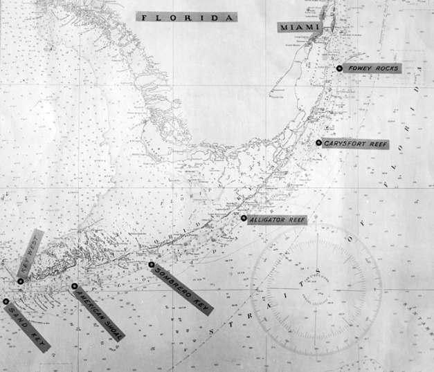
After paddling out to Miami’s Fowey Rocks Light, Key Largo’s Carysfort Light, Islamorada’s Alligator Reef Light, Marathon’s Sombrero Reef Lighthouse and Sugarloaf’s American Shoal Lighthouse – the last one in the chain is the Sand Key Lighthouse off Key West!
All these South Florida lighthouses were built in the 19th and early 20th centuries and also include four more land-accessible lighthouses: the Cape Florida Lighthouse, the Hillsboro Inlet Lighthouse, the Jupiter Inlet Lighthouse and historic Key West Lighthouse.
.

Sand Key light on the horizon as seen from Ft Zachary Taylor State Park, summer 2020.
Super telephoto view, eight miles away as the Man-o’-war bird flies!
.
Sand Key Lighthouse has a long history which involves two lighthouses, many hurricanes, several keepers quarters, nesting birds and a sometimes there, and sometimes not island – aka Sandy Key. Two hundred years ago this was an actual island at least 150 x 50 feet. In more recent memory it has been more of a shifting shoal, sometimes disappearing altogether, sometimes a small sand bar. Today it’s just a tiny shoal, barely big enough to park a kayak or two on. I did not know what to expect paddling out there in the summer of 2020, but was hoping for some dry land!
.

Ft Zachary Taylor State Park occupies the south west corner of Key West and is an excellent location for day trips around the island.
The Park is a nice change of pace from the otherwise touristy and people crazy Key West!
.
Key West is the closest point of land to access Sand Key and the lighthouse. Although there are other choices, I determined that for my purposes, Ft Zachary Taylor State Park would be the best place to launch from. It’s a beautiful park with a nice sandy beach and a dedicated paddle craft launching area. It’s also a great chill change of pace from people crazy Key West!
.

This is the actual and rather narrow paddle craft launching corridor on the park beach.
In reality it’s all that’s needed.
Note that upon entry, you will be asked to file a float plan if you plan to launch here!
.
This was another solo paddling excursion, though I would generally discourage anyone from paddling out into open water solo. If you decide to do a paddle like this, I recommend you use the buddy system and file a float plan with someone who can check up on you. Things don’t always go as planned and there are many things that can go wrong when you are out to sea. There are unpredictable factors like the weather which can also put you into jeopardy and you do not want to be out there all by yourself.
That being said, I realize that the above statement might make me sound like a hypocrite, however there is a method to my madness! I generally avoid weekend paddling and thus it can be really difficult to find other capable paddlers able to go during the work week. Sometimes paddling partner(s) cancel out at the last minute. Other times I choose to go solo in order to be in the right frame of mind as to what “feels” right (i.e. artist’s prerogative). It lets me do all the photography I want, do the trip the way I want, etc. I always thoroughly research my options before hand and then pick the most favorable conditions and equipment suitable to the trip. I am prepared to face some reasonable risk and deal with the consequences if need be!
.
.
.
The choice of boat for a particular trip is like choosing the right tool for the job. Sure, you can probably do a trip like this with shorter boats given enough stamina and dedication. However longer distances will favor faster, longer and sleeker boats. My old surfski “ONE WAY” fits the job description well. It is very fast, relatively comfortable and stable, and as a sit on top design makes snorkeling super easy. Also, one could argue that it is a superior and safer setup for tropical touring than a traditional sit inside sea kayak. I would actually rate this boat as my safest option for offshore paddling. This is because I rebuilt her with probably more than half styrofoam by volume inside!
Since ONE WAY is a sealed boat, everything has to go on top of the deck. I’ve customized her with extra fittings for lines and bungees to make this easier. Primarily I use a low profile “fish cooler” insulated pack that attaches at six points just behind the seat. Inside I carry the absolute minimum needed to safely and effectively complete the trip. So I had 6 litres of water in a bladder (1.5 gallons), an extra 1 litre bottle, food and snacks, extra clothing, line, small drybag with phone/keys/wallet and another drybag with some camera gear. Behind the fish catch pack were my bungeed crocs along with the mandatory PFD. Behind that I had my mask, fins and snorkel under bungees. In front of me I have a velcro strip on top of the footwell hump where I can attach a compass and my waterproof camera. That’s it!
Well, almost. I also made sure I had close to the perfect forecast!
.

ONEWAY is my vintage fishform touring surfski, perfect for this kind of trip.
Surfski center stringer repair and the Findeisen Shearwater resurrection!
.
Note:
I am describing a 16 mile open water round trip with NO possibility of getting out anywhere. Plan accordingly and paddle within your limitations and the weather conditions!!
Be absolutely sure you know what you are getting into before considering doing this kind of a trip!
Safety first means planning and research first!!
Always have plenty of fresh water to stay hydrated!
.
.
This story completes my project of paddling out to
all six of the offshore reef lights in the Florida Keys!
.
.

In a surfski averaging 5 mph or more isn’t too difficult. I also had some swells and waves to ride en route to Sand Key! 🙂
.
Driving down to Key West, I noted some early morning storm activity on the ocean side. By the time I was ready to launch from Ft Zachary Taylor State Park, there was a good one developing to the east. After observing it’s track I determined it was moving due NW and decided to launch quickly in order to outrun it on a SW heading! Within a couple of miles paddling my hunch to outrun the morning storm proved correct. About mid way through the 8 mile trip, a couple of charter fishing boats came by to check up on me. They may have never seen anyone paddle out that far before. I thanked them!
.
.

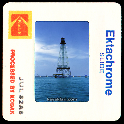
This is the second Sand Key Lighthouse which stands today and is of the skeletal iron construction type. It was erected in 1853 and seen in this photo circa 1910.
Image source: Photo courtesy Library of Congress (1910).
.

Sand Key and lighthouse circa 1967 with a bit of island still left!
Image source: Sand Key Lighthouse, Sand Key, Key West, Monroe County, FL
.
.
I made pretty good time, reaching the lighthouse in an hour and a half. Upon arrival I was really happy to see that in fact there was a tiny little shoal of dry ground on the east side, maybe about 30ft long and 6ft wide! I was catching it at just before low tide on this day and would certainly be leaving again before mid-tide flood. The tide differential out there is only about a foot, but even so this shoal would be just submerged at high tide. What’s left of Sand Key isn’t really sand, but more like small pieces of coral and ground up shells, etc. It is the nature of these shoals to shift over time, so there is no guarantee that it will be there in the future. Likely it will shift to another location or disappear completely again.
This is why you can never count on any dry ground at Sand Key!
.
.

Sand Key used to be a sizeable island in the 19th century. In the 21st century it’s a wild card; some years there’s a shoal, other years just water.
.
.

Sketch by William Adee Whitehead of the original Sand Key Lighthouse circa 1834.
It was a brick masonry structure built in 1827 but destroyed by a very strong hurricane in 1846.
Reprint from the U. S. Lighthouse Society’s “The Keeper’s Log” — Summer 2003
.
The original Sand Key Lighthouse was built in 1827!
.

Possibly the earliest depiction of Sand Key from 1830s, showing the original brick lighthouse and keepers home.
Reprint from the U. S. Lighthouse Society’s “The Keeper’s Log” — Summer 2003
.

Sketch of Sand Key from 1863!
Image source: Sand Key Lighthouse, Sand Key, Key West, Monroe County, FL
.
The original Sand Key Lighthouse was totally destroyed by a powerful hurricane in 1846, and the 140-ton lightship “Honey” was then anchored nearby as a temporary substitute.
Finally in 1853 a new skeletal iron type lighthouse was erected, the one still standing today.
Click for:
The history of the two Sand Key lighthouses
( PDF reprinted from The Keeper’s Log — Summer 2003 www.uslhs.org )
.

Sand Key Lighthouse on July 1, 1892 with guests on the sandy beach.
U.S. Lighthouse Society – Lighthouse Research Catalog collection.
.
The iron screw pile construction method for Sand Key light utilizes 17 load bearing piles as compared to the more typical 8 found in the other offshore lighthouses. This gives the lighthouse a very distinctive and immediately recognizable pyramid like design. It has proven to be very strong, having survived numerous fierce storms and hurricanes that have repeatedly washed away the Sand Key (island) itself!
On July 16, 2020 ..
.

Satellite view of Sand Key in 2017, we can still see the similar triangular outline of the 19th century key.
.
Station SANF1 – Sand Key
.

Latest 2017 satellite view shows a spit of sand to the south. By 2020 this had shifted to the east of the lighthouse!
.
.

Sand Key Lighthouse on July 16, 1899 – looking due east.
Image source: floridamemory.com
.
Oh, what synchronicity?!
.
.
.
Two picnics exactly a 121 years apart!
.

A watermelon picnic under the Sand Key Lighthouse on July 16, 1899!
Image source: floridamemory.com
.
.

Sand Key light in 1900.
Image source: Sand Key Lighthouse, Sand Key, Key West, Monroe County, FL
.

By 1950 the island was almost gone, leaving just the lighthouse and dock.
Photo source: USCG Archives
.
.

A peek a lil over 20ft up at the keepers quarters deck. The whole structure burned in 1989.
.

Fisheye panorama of the base of Sand Key light with Station SANF1 to the right.
.
.
.
.
.
.

This part hasn’t changed much since this 1967 even with little or no maintenance.
Image source: Sand Key Lighthouse, Sand Key, Key West, Monroe County, FL
.
.
.
.
.
Note:
I am describing a 16 mile open water round trip with NO possibility of getting out anywhere. Plan accordingly and paddle within your limitations and the weather conditions!!
Be absolutely sure you know what you are getting into before considering doing this kind of a trip!
Safety first means planning and research first!!
Always have plenty of fresh water to stay hydrated!
.

Sand Key Lighthouse iron footing disc support, circa 1967.
Image source: Sand Key Lighthouse, Sand Key, Key West, Monroe County, FL
.
.
These large iron discs were an important innovation in the mid to late 19th century when these iron pile skeletal frame lighthouses were being built. They helped to spread out the weight to reinforce the foundation screw or pile, often driven 10ft deep into the coral and or soft limestone bedrock.
.

Here we can see that in 2020, some discs are in great shape, others completely undermined and wholly compromised!
.
.
The innovative screw pile and footing discs were developed by Alexander Mitchell in Ireland. He was a self taught blind engineer who pioneered this technology for use in silty and sandy soils. It proved perfect for the Florida offshore lighthouses as they have all withstood numerous storms and hurricanes over the many decades. Of course, the lights are now in need of restoration and maintenance if they are to continue standing over the reefs!
Sand Key Lighthouse history
.

19th century illustration of an iron screw pile being driven into the soft coral limestone rock. The workers are standing on a platform in open water. Sometimes draft animals were also used!
.
.
.
.
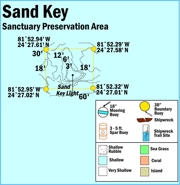
Sand Key has it’s own special Sanctuary Preservation Area which has further restrictions on allowed activities to help protect the health of the reef. The reef is similar other tracts in the lower keys. I only had enough time for a brief shallow excursion, but if you come to snorkel, there are several white mooring buoys to tie off to.
.
.
.
.
.
.
Sand Key Sanctuary Preservation Area
.
.

Colony of Orbicella annularis, aka Boulder Star Coral at Sand Key.
.

Close up of Orbicella annularis, showing beginning of bleaching.
.

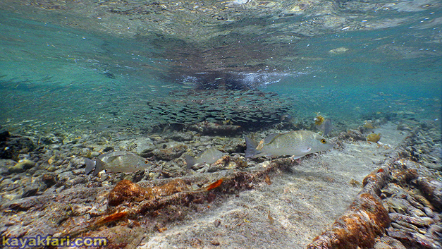
Sadly large sections of the shallows appear dead and covered with algae. Then there are lots of these organisms which seem to grow on top of that. Im not sure what this is, but it kinda looks like some kind of parasitic growth.
.
.
.

Sand Key Lighthouse in 1960.
Image source: floridamemory.com
.

Sand Key Lighthouse and weather station, colorized photo circa 1910!
Image source: Photo courtesy Library of Congress (1910).
.
.
.
.

I scooped up the larger mullet and repatriated them into the sea to prevent such an early and inglorious ending!
.
.
.
.
By 2017, Sand Key lighthouse was deemed surplus property by the USCG. Along with all the other (except Fowey Rocks) offshore keys lights, Sand Key was up for auction. On November 27, 2020, the auction closed with a high bid of $83,000 from an unknown entity. I do know that LighthouseFriends.com was however NOT the winner, so hopefully the new owner(s) will be able to restore and take care of this historic lighthouse!
.
.
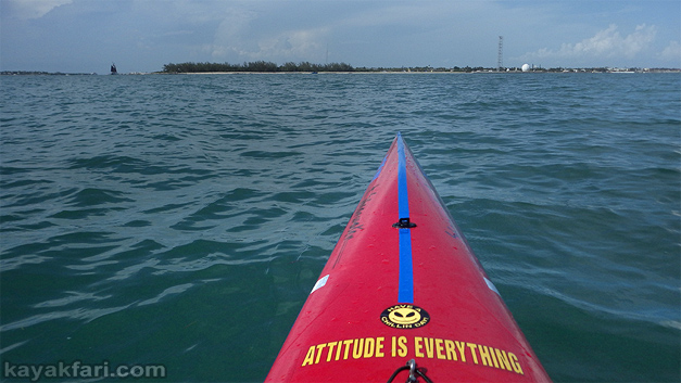
Almost the entire return trip was into a steady 15 kt headwind with resultant nasty annoying chop in shallow water which slowed me down considerably.
.
The return trip back to Key West took two hours because of a 15 knot headwind and resultant short chop. This is pretty much the least fun of upwind paddles because the short chop causes the boat to constantly slap on the backs of the waves. This slows the boat down considerably, I was lucky to average even only 4 knots.
~ ~ ~ ~ ~ ~ ~ ~ ~ ~ ~ ~ ~
.

Arrival back at Ft Zachary Taylor State Park after two hours of slapping into the waves. I went ONEWAY and made it back .. 😉
.
ONEWAY is a “rebuilt” vintage fish form surfski and makes an excellent tropical longer distance day cruiser.
See a comparison with a modern swede form ski:
A tale of two surfskis 20 years apart (Stellar SES vs Findeisen Shearwater).
.
.
.
The original masonry lighthouse at Key West was first lit on January 13, 1826. However it was also destroyed by the same 1846 hurricane that destroyed Sand Key light. On January 15, 1848, the current lighthouse was completed, later extended in height by about 25 feet in 1895.
I could easily see this light at Key West on my return approach, although it doesn’t seem so tall in comparison to the adjacent foliage and other buildings today.
.
.
Key West Lighthouse
.
.
My quest to paddle out to all
six Florida Keys offshore lighthouses is now complete!
🙂
.

“Day and night under the light!”
It would really be an incredible experience to spend a night under the lighthouse.
.

Then comes the drive back from the Keys. The divided US 1 highway makes it so much less stressful than it used to be~!
.
Please note:
I am describing a 16 mile open water round trip with NO possibility of getting out anywhere. Plan accordingly and paddle within your limitations and the weather conditions!!
Be absolutely sure you know what you are getting into before considering doing this kind of a trip!
Safety first means planning and research first!!
Always have plenty of fresh water to stay hydrated!
.
.
.
.
Be safe and enjoy your time
on the water and underwater!
🙂
.
You may also like:
.
.
.
.
.
.
.
.
.
.
.
.
© 2022 Flex Maslan / kayakfari.com / awakenthegrass.com. All original photographs, artworks and music in this portfolio are copyrighted and owned by the artist, Flex Maslan, unless otherwise noted. Any reproduction, modification, publication, transmission, transfer, or exploitation of any of the content, for personal or commercial use, whether in whole or in part, without written permission from the artist is strictly prohibited.
All rights reserved!
…
DISCLAIMER:
The maps and images on this site are not intended for navigation, I am not a guide; use any and all information at your own risk! Your mileage may vary .. so use good judgement before venturing out!
…
I hereby disclaim any sponsorship, endorsement, nor association with any product or service described herein. The photographs, depictions, products, and ideas presented on this site are for informational purposes only. Your results may vary, and I do not imply nor guarantee the effectiveness, suitability, design or operation to adhere to any standard. I assume no legal responsibility for the implementation of anything herein presented! Use any and all information at your own risk! By using any and all information from this website, you accept the final liability for any use or possible associated misuse!
.
With that said..
Blessings friends!
🙂












Great article – very thoroughly researched!
LikeLike