All original photographs, artworks and music in this portfolio are copyrighted and owned by the artist, Flex Maslan, unless otherwise noted. Any reproduction, modification, publication, transmission, transfer, or exploitation of any of the content, for personal or commercial use, whether in whole or in part, without written permission from the artist is strictly prohibited.
All rights reserved!
…
DISCLAIMER:
The maps and images on this site are not intended for navigation, I am not a guide; use any and all information at your own risk! Your mileage may vary .. so use good judgement before venturing out!
…
I hereby disclaim any sponsorship, endorsement, nor association with any product or service described herein. The photographs, depictions, products, and ideas presented on this site are for informational purposes only. Your results may vary, and I do not imply nor guarantee the effectiveness, suitability, design or operation to adhere to any standard. I assume no legal responsibility for the implementation of anything herein presented! Use any and all information at your own risk! By using any and all information from this website, you accept the final liability for any use or possible associated misuse!
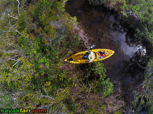
The hungry ghost of a gator snaps at inquisitive paddlers. Halloween on the Taylor Slough.
.
Grass paddling is a local Everglades specialty!
While free ranging is always possible, it’s usually best to save the energy by mostly sticking to (relatively) well established canoe and NPS airboat trails as much as possible. Poling, pushing, and paddling – it’s all good on the slough. This Halloween trip followed down the Taylor Slough and then the Craighead Pond Canoe Trail, eventually exiting at the Nine Mile Pond Canoe Trail. The upper part of Taylor Slough is a beautiful area, paddling amongst Cypress trees with mixed vegetation. Then the further south we went, the more open and prairie-like the landscape became. We kept moving across this wide open watery landscape until again being corralled into channels by coastal mangroves.
Then we ran out of daylight and it got real dark ..
The maps and images on this site are not intended for navigation, I am not a guide; use any and all information at your own risk! Your mileage may vary .. so use good judgement before venturing out!
…
I hereby disclaim any sponsorship, endorsement, nor association with any product or service described herein. The photographs, depictions, products, and ideas presented on this site are for informational purposes only. Your results may vary, and I do not imply nor guarantee the effectiveness, suitability, design or operation to adhere to any standard. I assume no legal responsibility for the implementation of anything herein presented! Use any and all information at your own risk! By using any and all information from this website, you accept the final liability for any use or possible associated misuse!
Chekika Island and Indian Key are forever linked by the infamous raid of 1840. Chekika and his men had to sail and paddle about 90 miles each way which took several days.
.
The infamous Indian Key raid and massacre that occurred
In the days leading up to this, Chekika’s band of warriors would have been traversing the Shark River Slough aka, the “River of Grass”. Once out of the slough, they would have navigated the maze of coastal mangroves and exited into Florida Bay probably in the vicinity of today’s Flamingo. The final stretch of about 30 miles across Florida Bay enabled them to reach the keys near Indian Key where they lay in wait to launch their surprise attack. There is plenty of information on the Indian Key attack itself, but not much on Chekika’s home base which was at the time hidden deep in the unknown Everglades.
Today thousands of daily motorists unknowingly drive right past it on their way to or from the west coast on the Tamiami Trail!
There is limited historical information about Chief Chekika, but he was said to be a man of great stature at over 6ft tall and 200lbs plus. He was a leader in his people’s struggle against the US Government’s genocidal policies, generally referred to as the Second Seminole War. This war was a direct result of a very dark chapter in American History called the Indian Removal Act of 1830 and the ensuing Trail of Tears. It’s because of this that dislocated native peoples were driven deeper down into Florida and eventually the Everglades. The systematic destruction of native culture, removal and outright genocide was official government policy. Sadly this grave injustice has yet to addressed by our government nearly 200 years later!
The earliest reference to Chekika is from July 23, 1839 when he led a successful raid on the Caloosahatchee Trading Post in which Lt col. Harney barely escaped with his life. It would appear that Harney then held a personal grudge against Chekika, and the events that unfolded next played right into this. Chekika’s plan was to raid the large stockpiles of salvage and other supplies stored in warehouses on Indian Key. These were owned and maintained by Captain Jacob Housman, who owned most the of island. On August 7, 1840 Chekika and his band of 60-130 warriors attacked and raided the Key in what is sometimes called the Indian Key Massacre. Upwards of 18 people were killed by the time mayhem was over including Dr. Perrine and the whole town was burned. Chekika’s band left Indian Key with 28 canoes and six of Houseman’s boats filled with all the loot. They sailed and paddled the 90 odd miles back to their base at Chekika Island hidden inside the endless Everglades.
The maps and images on this site are not intended for navigation, I am not a guide; use any and all information at your own risk! Your mileage may vary .. so use good judgement before venturing out!
…
I hereby disclaim any sponsorship, endorsement, nor association with any product or service described herein. The photographs, depictions, products, and ideas presented on this site are for informational purposes only. Your results may vary, and I do not imply nor guarantee the effectiveness, suitability, design or operation to adhere to any standard. I assume no legal responsibility for the implementation of anything herein presented! Use any and all information at your own risk! By using any and all information from this website, you accept the final liability for any use or possible associated misuse!
The Sweetwater chickee camping platform was next on our list. It lies tucked away inside a little ‘finger cove’ of Sweetwater Bay. It is also pretty close to the Everglades interior (i.e. the slough) so the tidal influence was minimal here. I tasted the water and it was pretty sweet, probably good enough to filter. However this may not always be the case at other times of the year!
(tap or click pic to read)
The Sweetwater chickee is aptly named for the water was indeed sweeter! Heaven or Hell: Summer paddling and camping in the Ten Thousand Islands
.
Paddling in the summer heat really feels like being in a steam bath. I tried dunking myself in the water to cool off, but it was not very effective since the water felt like a hot tub. Still, the evaporation of the water did help a tiny bit. I was glad that I used an old somewhat leaky nylon spray skirt rather than my neoprene nice fitting one. The porousness did keep me cooler!
Some people bring sports drinks for hydration. I rely mostly on plain water supplemented with rations of young cocoanut water to replenish the sweated out salts. If you go paddling in the summer, it bears repeating:
Bring twice the amount of drinking water you think you’ll need!
The maps and images on this site are not intended for navigation, I am not a guide; use any and all information at your own risk! Your mileage may vary .. so use good judgement before venturing out!
…
I hereby disclaim any sponsorship, endorsement, nor association with any product or service described herein. The photographs, depictions, products, and ideas presented on this site are for informational purposes only. Your results may vary, and I do not imply nor guarantee the effectiveness, suitability, design or operation to adhere to any standard. I assume no legal responsibility for the implementation of anything herein presented! Use any and all information at your own risk! By using any and all information from this website, you accept the final liability for any use or possible associated misuse!
Here’s looking at Euclid! 😉 Pahayokee Overlook to Main Street – Probing into the middle of Shark River Slough.
.
“Too deep for walking and too shallow for boating”.
There is a well known airboat trail known as “Main Street” which runs the length of the largest slough inside of Everglades National Park. This path is not open to the general public for airboating, however it does enable paddlers to transit the length of the famed “River of Grass”. The Shark River Slough runs from the Tamiami Trail down to Bottle Creek at the south end, where navigable water leads eventually connect to the Canepatch backcountry campsite. The purpose of this trip was to to try and connect to Main Street from the Pahayokee Overlook, as a shorter alternate route to get to Canepatch!
The maps and images on this site are not intended for navigation, I am not a guide; use any and all information at your own risk! Your mileage may vary .. so use good judgement before venturing out!
…
I hereby disclaim any sponsorship, endorsement, nor association with any product or service described herein. The photographs, depictions, products, and ideas presented on this site are for informational purposes only. Your results may vary, and I do not imply nor guarantee the effectiveness, suitability, design or operation to adhere to any standard. I assume no legal responsibility for the implementation of anything herein presented! Use any and all information at your own risk! By using any and all information from this website, you accept the final liability for any use or possible associated misuse!
Wet surfski workout session paddling through Port Everglades in Ft Lauderdale. Paddling in the Rain, Just Paddlin’ and Campin’ in the Rain .. sing along!
The maps and images on this site are not intended for navigation, I am not a guide; use any and all information at your own risk! Your mileage may vary .. so use good judgement before venturing out!
…
I hereby disclaim any sponsorship, endorsement, nor association with any product or service described herein. The photographs, depictions, products, and ideas presented on this site are for informational purposes only. Your results may vary, and I do not imply nor guarantee the effectiveness, suitability, design or operation to adhere to any standard. I assume no legal responsibility for the implementation of anything herein presented! Use any and all information at your own risk! By using any and all information from this website, you accept the final liability for any use or possible associated misuse!
The “Widowmaker” meant pushing, pulling or throwing boats over mangroves as necessary! Crossing paths of Gladesmen, Gator hunters, Outlaws and Moonshiners: An invitation to paddling forgotten trails of the Everglades!
.
The Bill Ashley Jungles is an area west of the main Park road roughly between Paurotis Pond and Hell’s Bay, and we were right in the middle of it! Historically these were productive hunting grounds for both Native American tribes and later “Cracker” gator hunters and trappers. This landscape has also changed over the decades, with brackish water intruding northwards, resulting in the predominantly wet mangrove forest habitat that we saw. It certainly did not look like it to us, but back in the 1920′-30’s there was abundant game deer to be had here! Today this is a largely forgotten area, except for the Hell’s Bay Canoe Trail that runs through a part of it. This single trail probably the single most popular paddling route inside of Everglades National Park.
Paradoxically this area is at once the most visited,
yet also the least explored!
The Bill Ashley Jungles were named after a band of outlaws who hid out in the Glades in the 1910’s-20’s called the Ashley Gang, led by John Ashley and his “queen”, Laura Upthegrove. Back then almost everything in South Florida was still the “Everglades”, so whether you were in Homestead or Jupiter, you’d still be in the “Everglades”. It was more of a question of how hard it was to get in and out. By 1924 members of the close knit Ashley Gang family were either in custody or dead. Bill Ashley, one of John’s brothers was apprehended in January 1924, and was the only one who actually survived the family “business” and then lived out his years in Pompano Beach until his death in 1940.
The maps and images on this site are not intended for navigation, I am not a guide; use any and all information at your own risk! Your mileage may vary .. so use good judgement before venturing out!
…
I hereby disclaim any sponsorship, endorsement, nor association with any product or service described herein. The photographs, depictions, products, and ideas presented on this site are for informational purposes only. Your results may vary, and I do not imply nor guarantee the effectiveness, suitability, design or operation to adhere to any standard. I assume no legal responsibility for the implementation of anything herein presented! Use any and all information at your own risk! By using any and all information from this website, you accept the final liability for any use or possible associated misuse!
Miami adventurer Leah stands up in her sea kayak and surveys the sea of grass. Grass Paddling in the East Everglades Expansion Area – History, Gladesmen & more Grass!
.
The airboater was quite surprised to see a bunch of canoeists and kayakers already there at the dock, including (then) Everglades National Park Superintendent Dan Kimball!
Out on this sea of grass, it’s important to be able to stand up and see over all the tall grass! This is easy in a canoe, but much harder in a narrow sea kayak. Fortunately, the shallow depth and extensive vegetation cradle the hull and make this easier. Using the paddle as a support pole also helps.
The biggest challenge to paddling a long sea kayak in the grass is that you have to pick your line exactly and stick with it! The long kayak acts a lot like a knife blade – easy to push through the vegetation, but nearly impossible to turn sideways from a dead stop. It really helps to keep constantly moving, and you need to edge the boat because the rudder or rudder strokes are useless and unworkable in the grass. The few times I got off track I had to back up like a semi truck (beep beep .. beep beep) and start my line up again!
The maps and images on this site are not intended for navigation, I am not a guide; use any and all information at your own risk! Your mileage may vary .. so use good judgement before venturing out!
…
I hereby disclaim any sponsorship, endorsement, nor association with any product or service described herein. The photographs, depictions, products, and ideas presented on this site are for informational purposes only. Your results may vary, and I do not imply nor guarantee the effectiveness, suitability, design or operation to adhere to any standard. I assume no legal responsibility for the implementation of anything herein presented! Use any and all information at your own risk! By using any and all information from this website, you accept the final liability for any use or possible associated misuse!
I spotted what at first looked like a junk plastic bottle from a distance. Post Hurricane Irma high water paddling in the Everglades!
.
I found this pint size flask bottle in the Everglades near Sweet Bay Pond, very close to where the old Ingraham Highway made a sharp 90 degree turn due south towards Flamingo.
It pertains to a Federal law that went into effect in 1935 and was on the books until 1964.
The law was intended to prevent illegal distillers from refilling legitimate bottles with their moonshine!
This is a vintage bottle from the post-Prohibition era!
So it’s not quite a cultural artifact, and whether or not it was part of a clandestine moonshine operation or just somebody’s personal refuse we shall never know. But there were many moonshine operations in the Everglades for years even after the end of Prohibition!
The maps and images on this site are not intended for navigation, I am not a guide; use any and all information at your own risk! Your mileage may vary .. so use good judgement before venturing out!
…
I hereby disclaim any sponsorship, endorsement, nor association with any product or service described herein. The photographs, depictions, products, and ideas presented on this site are for informational purposes only. Your results may vary, and I do not imply nor guarantee the effectiveness, suitability, design or operation to adhere to any standard. I assume no legal responsibility for the implementation of anything herein presented! Use any and all information at your own risk! By using any and all information from this website, you accept the final liability for any use or possible associated misuse!
Represent! Flying the colors at the launch in Everglades City. Moonshine in the 10 000 Islands of the Everglades.
.
A simple “overnight” trip,
but with about 42 miles to cover.
On offer in this story is a photo journey of a quest to find a “lost” bit of old Everglades history. It’s the story of a Prohibition era liquor still hidden deep in the mangrove jungles of the Ten Thousand Islands.
It takes us back to the beginnings of the fascinating life story of Chokoloskee resident Loren “Totch” Brown who lived there. If you are not familiar, his book is a must read:
With the Liquor Still Bay mission accomplished, we headed out into the Gulf on a slack tide. The paddling was easy and serene, and not at all what the Gulf waters would have waiting in store for us.
The maps and images on this site are not intended for navigation, I am not a guide; use any and all information at your own risk! Your mileage may vary .. so use good judgement before venturing out!
…
I hereby disclaim any sponsorship, endorsement, nor association with any product or service described herein. The photographs, depictions, products, and ideas presented on this site are for informational purposes only. Your results may vary, and I do not imply nor guarantee the effectiveness, suitability, design or operation to adhere to any standard. I assume no legal responsibility for the implementation of anything herein presented! Use any and all information at your own risk! By using any and all information from this website, you accept the final liability for any use or possible associated misuse!
Emerging from the refuge of the micro-tent / cage after 12+ hours. Camping Hell in the Ten Thousand Islands.
.
Revised and updated for your reading pleasure!
Starting with a late departure, this trip seemed all about pushing our luck. It was a 3 day and 3 night kinda trip, if that makes any sense? The idea was to revisit the liquor still in the Everglades we had found earlier, and also see a bunch of places en route. We explored the Gopher Key Calusa mound and then rode Charley Creek out into the Gulf of Mexico, followed by camping at Pavilion Key.
Thanks to skill, perseverance and some luck we were able to visit
all the spots as planned, however the camping was just plain ugly!!
The maps and images on this site are not intended for navigation, I am not a guide; use any and all information at your own risk! Your mileage may vary .. so use good judgement before venturing out!
…
I hereby disclaim any sponsorship, endorsement, nor association with any product or service described herein. The photographs, depictions, products, and ideas presented on this site are for informational purposes only. Your results may vary, and I do not imply nor guarantee the effectiveness, suitability, design or operation to adhere to any standard. I assume no legal responsibility for the implementation of anything herein presented! Use any and all information at your own risk! By using any and all information from this website, you accept the final liability for any use or possible associated misuse!
I began to dress like them to fit in, and soon they began to accept me as one of their own. ART of Cape Romano – The curious inhabitants of Australopithecine Island.
.
On a remote island in the Ten Thousand Islands area of the Everglades an isolated tribe of curious Australopithecines took up residence in the Cape Romano dome ruins. For years the clan lived in harmony subsisting on a diet of mostly fish, marine life and herbs. Sometimes they would find ready made food containers with half eaten sandwiches and salads, presumably left behind by the “hairless ones” (whom we call tourists).
These were “feast” days to them, and the living was good!
The hominins soon learned that the “hairless ones” would come twice a day, morning and afternoon, almost like the movement of tides. They would watch from their hiding places and later find other objects the “hairless” sometimes left behind. They made good use of all the things left to them like tents, tarps and plastic cups and wood pieces!
The first Australopithecine I ever met, I named him “George” due to his curious nature! There was also at least one female of breeding age and I called her “Lucy”, along with a young juvenile male “Diego”. Where in the world did he come from?
The maps and images on this site are not intended for navigation, I am not a guide; use any and all information at your own risk! Your mileage may vary .. so use good judgement before venturing out!
…
I hereby disclaim any sponsorship, endorsement, nor association with any product or service described herein. The photographs, depictions, products, and ideas presented on this site are for informational purposes only. Your results may vary, and I do not imply nor guarantee the effectiveness, suitability, design or operation to adhere to any standard. I assume no legal responsibility for the implementation of anything herein presented! Use any and all information at your own risk! By using any and all information from this website, you accept the final liability for any use or possible associated misuse!
Pedal and Paddle at Shark Valley: The kayak and the wheel, a symbiotic relationship. Kayaking at Shark Valley – A visit to Seagrape Hammock, aka Willoughby Key!
.
The lunatics are on the Grass,
Got to keep those loonies off the trail!
.
Everglades exploration and photography in the style of the classic1898 book “Across the Everglades“, by Hugh L. Willoughby.
This is a story of a “pedal and paddle” visit to a small tree island hammock in the Everglades “River of Grass”. We used bicycles, a trailer and a tandem SOT kayak to ride down the tram road and paddle through the grass to the island. The Shark Valley tower happens to be only a short distance from this tree island called “Seagrape Hammock” in the middle of the Shark River Slough. Hugh L. Willoughby wrote about the island in his classic 1898 book – “Across the Everglades” and dubbed it “Willoughby Key”. He kept excellent records and published the accurate coordinates in his book, so we know for a fact that it is Seagrape Hammock.
He actually liked this island so much that he camped there twice!
Why go to Seagrape Hammock? Well there’s the historical connection already mentioned that gives us a window into the Everglades of old circa 1898. At that time, the Everglades were largely still untouched and pristine. The Seminole Native Americans were still able to live a largely traditional subsistence way of life. The Everglades were clean, bountiful and unfettered. However within a generation afterwards, the irreversible system wide alterations and damage to the Everglades ecosystem would begin. So Willoughby’s descriptions are among the last of the real Everglades as they had existed for millennia prior!
I had been fascinated with this tree island ever since sighting it during a trip down the Shark River slough in 2012. But on that trip we passed close within a mile, although couldn’t take the time for the detour. On this trip we succeeded and I had plenty of time to explore and photograph the Seagrape Hammock tree island!
Geographically, Seagrape Hammock is situated roughly halfway in between the Cypress strands of Big Cypress to the west and the higher (now developed) Pineland ridge to the east.
The maps and images on this site are not intended for navigation, I am not a guide; use any and all information at your own risk! Your mileage may vary .. so use good judgement before venturing out!
…
I hereby disclaim any sponsorship, endorsement, nor association with any product or service described herein. The photographs, depictions, products, and ideas presented on this site are for informational purposes only. Your results may vary, and I do not imply nor guarantee the effectiveness, suitability, design or operation to adhere to any standard. I assume no legal responsibility for the implementation of anything herein presented! Use any and all information at your own risk! By using any and all information from this website, you accept the final liability for any use or possible associated misuse!
The neon day-glo airboat Mothership of the Everglades with kayaks! Grass paddling and poling in the Everglades Water Conservation Areas.
.
In the permanently flooded Water Conservation Areas of the Glades, the airboat is the best way to get around and reach fishing and hunting grounds and private camps. Still there is something very pure and beautiful being out on the water where it’s just you, the boat and your pole or paddle.
Moving through the landscape at a human pace can be hard work,
but can also be immensely satisfying for body, mind and soul!
Times are changing again for the Everglades, this time for the better. Let’s face it, people care most about the things they know and love. Additional human powered access whether on foot, boat or even bicycle can raise awareness and help drive Everglades Restoration efforts for generations forward!
The maps and images on this site are not intended for navigation, I am not a guide; use any and all information at your own risk! Your mileage may vary .. so use good judgement before venturing out!
…
I hereby disclaim any sponsorship, endorsement, nor association with any product or service described herein. The photographs, depictions, products, and ideas presented on this site are for informational purposes only. Your results may vary, and I do not imply nor guarantee the effectiveness, suitability, design or operation to adhere to any standard. I assume no legal responsibility for the implementation of anything herein presented! Use any and all information at your own risk! By using any and all information from this website, you accept the final liability for any use or possible associated misuse!
My mud salvation in the Everglades. The Lost Portage – connecting streams in the Everglades!
.
The term “Lost Portage” is used to describe an
inland connection between two streams originating
from the the Shark River Slough aka the “River of Grass”.
The reason for going through this Lost Portage is to go directly between two of the most remote Everglades backcountry campsites – Canepatch and Camp Lonesome. Any paddler considering camping at these sites would think it obvious that there should be a direct inland connection between them, but officially there is not! So the typical Wilderness Waterway paddler is directed to either head out into the Gulf, or go through a mangrove creek called the “Nightmare”. Either option means a long paddle out and then back in, closer to the interior. A direct connection is much shorter though probably more challenging!
Before they become actual rivers of the Everglades:
connecting the Broad River and the Harney – Shark Rivers.
Due to the distances involved, logistics and time constraints during the winter Holiday break, I laid out a 4 day and 3 night weather balloon shaped route. It was the only realistic way to run this trip, as neither me nor my paddling partner were willing to take off a whole week.
This fairly ambitious schedule would have us close the gap in the
shortest amount of time with some long daily paddling miles!
The maps and images on this site are not intended for navigation, I am not a guide; use any and all information at your own risk! Your mileage may vary .. so use good judgement before venturing out!
…
I hereby disclaim any sponsorship, endorsement, nor association with any product or service described herein. The photographs, depictions, products, and ideas presented on this site are for informational purposes only. Your results may vary, and I do not imply nor guarantee the effectiveness, suitability, design or operation to adhere to any standard. I assume no legal responsibility for the implementation of anything herein presented! Use any and all information at your own risk! By using any and all information from this website, you accept the final liability for any use or possible associated misuse!
The One-mile Tamiami Trail bridge has started a new chapter for the Everglades! Paddling under the Everglades Skyway – the one-mile Tamiami Trail bridge over Shark River slough.
.
The completion of this bridge as the first segment of an “Everglades Skyway” was a major milestone in Everglades Restoration efforts now underway. By 2024 a series of bridges will replace sections of the Tamiami Trail (Hwy 41) which has been the dividing line in the Everglades since 1928! This will help to restore historic water flow into the Shark River slough, otherwise known as “The River of Grass”. Realistically, the Everglades will never be as it was before the drastic human interventions of the last century. Too much irreversible and permanent damage has been done.
However with careful science-based research,
planning and management,
we should be able to get a functioning Everglades ecosystem again!
The maps and images on this site are not intended for navigation, I am not a guide; use any and all information at your own risk! Your mileage may vary .. so use good judgement before venturing out!
…
I hereby disclaim any sponsorship, endorsement, nor association with any product or service described herein. The photographs, depictions, products, and ideas presented on this site are for informational purposes only. Your results may vary, and I do not imply nor guarantee the effectiveness, suitability, design or operation to adhere to any standard. I assume no legal responsibility for the implementation of anything herein presented! Use any and all information at your own risk! By using any and all information from this website, you accept the final liability for any use or possible associated misuse!
The event’s special guest was Daniella Levine Cava, the Mayor of Miami-Dade County. She and her husband Dr Rob Cava are both avid canoeists! Everglades Invitational 2021 on the Nine Mile – Craighead Pond route!
.
This year’s event was held in the Nine Mile Pond and Craighead Pond areas east of the Park road and just north of the mangrove forests that border Florida Bay. The Everglades Invitational 2021 Paddling Event was a success and we have resurrected a yearly Everglades tradition of sorts.
We paddled all day long, right into a glorious sunset!
The maps and images on this site are not intended for navigation, I am not a guide; use any and all information at your own risk! Your mileage may vary .. so use good judgement before venturing out!
…
I hereby disclaim any sponsorship, endorsement, nor association with any product or service described herein. The photographs, depictions, products, and ideas presented on this site are for informational purposes only. Your results may vary, and I do not imply nor guarantee the effectiveness, suitability, design or operation to adhere to any standard. I assume no legal responsibility for the implementation of anything herein presented! Use any and all information at your own risk! By using any and all information from this website, you accept the final liability for any use or possible associated misuse!
An outback plein air apartment on the creek. Gone up Crooked Creek to have a little chickee camping fun!
.
At about 9 miles out from the Park launch at Everglades City it sits between the Lopez River and Sunday Bay. The paddling distance is about the same whether you come up the Lopez River from the Gulf side or paddle inside via the Turner River.
The Crooked Creek chickee is well positioned as an easy
first night camp for many Ten Thousand Islands trips.
The maps and images on this site are not intended for navigation, I am not a guide; use any and all information at your own risk! Your mileage may vary .. so use good judgement before venturing out!
…
I hereby disclaim any sponsorship, endorsement, nor association with any product or service described herein. The photographs, depictions, products, and ideas presented on this site are for informational purposes only. Your results may vary, and I do not imply nor guarantee the effectiveness, suitability, design or operation to adhere to any standard. I assume no legal responsibility for the implementation of anything herein presented! Use any and all information at your own risk! By using any and all information from this website, you accept the final liability for any use or possible associated misuse!
“You keep on knocking, but you can’t come in!” Of Bugs and Men, Chapter 1 – Noseeums.
.
I termed this story “Of Bugs and Men”, though they will bite anyone with equal opportunity. They do not discriminate, and to them we are all gender neutral.
The only exception might be first time virgin campers of the Everglades which noseeums consider a delicacy! 😉
As with mosquitoes, only the females feed on the blood of vertebrates, which they need for their eggs to mature. They can also easily fly for a couple of miles and will be lured in by the CO2 that we all exhale. So unless there’s a strong breeze or you are on an offshore sandbar island, chances are you will encounter them.
The maps and images on this site are not intended for navigation, I am not a guide; use any and all information at your own risk! Your mileage may vary .. so use good judgement before venturing out!
…
I hereby disclaim any sponsorship, endorsement, nor association with any product or service described herein. The photographs, depictions, products, and ideas presented on this site are for informational purposes only. Your results may vary, and I do not imply nor guarantee the effectiveness, suitability, design or operation to adhere to any standard. I assume no legal responsibility for the implementation of anything herein presented! Use any and all information at your own risk! By using any and all information from this website, you accept the final liability for any use or possible associated misuse!
This is some of the stickies, clingiest, and bottomless muck that there is! Barron Creek to Ferguson River Loop – Mangroves, Airboats and Mud.
.
That said, the area is beautiful, particularly the mangrove tunnels in the eastern section and the “prairie” zone just past that. The mangrove tunnels are possibly some of the most striking that you’ll find anywhere. This is why they run tourist airboat tours here. After this you’ll come into a cove with some of the stickiest, clingiest & bottomless quicksand / mud that there is!
If you capsize here for some reason .. well good luck! 😮
The maps and images on this site are not intended for navigation, I am not a guide; use any and all information at your own risk! Your mileage may vary .. so use good judgement before venturing out!
…
I hereby disclaim any sponsorship, endorsement, nor association with any product or service described herein. The photographs, depictions, products, and ideas presented on this site are for informational purposes only. Your results may vary, and I do not imply nor guarantee the effectiveness, suitability, design or operation to adhere to any standard. I assume no legal responsibility for the implementation of anything herein presented! Use any and all information at your own risk! By using any and all information from this website, you accept the final liability for any use or possible associated misuse!
Paddling down “Main Street” in the middle of Shark River Slough in the Everglades. Kayaking the River of Grass – a Shark River Slough Expedition.
.
Out here, you hear EVERYTHING! There is silence here, but more often than not, we would hear distant rumbles and the sounds of machines. Airboats from the “Everglades Ecotours” tourist rides just east and north of the park, the buzz of many small and private planes flying and training overhead .. airliners on final approach to MIA. The Shark River Slough feels remote, but is not nearly as quiet as the Taylor Slough.
Paddling in this upper section of the Park is true grass paddling, a seemingly endless realm of water and grass punctuated only by tree hammocks of various sizes. Many of the larger ones were used in the past by native Indian tribes, and later by Gladesmen as hunting camps, etc. On our route we came within just a few miles SE of the Shark Valley tower, and we could see it’s distinct shape in the distance.
On the critical section where we would come to intersect what is called “Main Street”, which is a well defined airboat trail that runs down the middle of the slough.
This trail would takes us all the way into Bottle Creek on the southern edge of the slough!
The maps and images on this site are not intended for navigation, I am not a guide; use any and all information at your own risk! Your mileage may vary .. so use good judgement before venturing out!
…
I hereby disclaim any sponsorship, endorsement, nor association with any product or service described herein. The photographs, depictions, products, and ideas presented on this site are for informational purposes only. Your results may vary, and I do not imply nor guarantee the effectiveness, suitability, design or operation to adhere to any standard. I assume no legal responsibility for the implementation of anything herein presented! Use any and all information at your own risk! By using any and all information from this website, you accept the final liability for any use or possible associated misuse!
Good morning sunshine, the air is sweet at the Cane Patch! Canepatch camp site deep in the Everglades – a former Indian Mound (Avocado Mound).
.
Canepatch is far away from everywhere,
but as they say – location is everything.
The Cane Patch is a large clearing with a small dock maintained by the Park Service as an official campsite. Formerly known as “Avocado Mound”, it was cultivated and occupied by native peoples for hundreds of years at least, perhaps thousands. It’s location along the transition between the salty coastal mangrove forests and freshwater slough (The River of Grass) of the Everglades would be akin to a rest stop on a superhighway today. High, dry ground can be scarce to find in this region, and this site was cleared and built up as a mound by native people who also cultivated some crops. It was one of several in a network of mounds that natives built up, maintained and seasonally lived on. Certainly right up to the establishment of Everglades National Park itself there were people living and farming at Cane Patch, with the name itself giving away at least one of the crops commonly grown by cracker settlers in the Everglades!
Evidence of cultivation can still be readily seen in the vegetation which is like a small botanical garden!
The maps and images on this site are not intended for navigation, I am not a guide; use any and all information at your own risk! Your mileage may vary .. so use good judgement before venturing out!
…
I hereby disclaim any sponsorship, endorsement, nor association with any product or service described herein. The photographs, depictions, products, and ideas presented on this site are for informational purposes only. Your results may vary, and I do not imply nor guarantee the effectiveness, suitability, design or operation to adhere to any standard. I assume no legal responsibility for the implementation of anything herein presented! Use any and all information at your own risk! By using any and all information from this website, you accept the final liability for any use or possible associated misuse!
First of many mangrove traffic jams. 😮 Mahogany Hammock – Lane Bay loop of the 2017 Invitational paddle!
.
This “Invitational” Everglades paddling event was held in a seemingly endless maze-like area southwest of the Mahogany Hammock Trail inside Everglades National Park. The trip was organized by contemporary Everglades explorer Terry Helmers of the Everglades Exploration Network. Terry likes to go well off the beaten path and plans these trips right near the end of the Everglades wet season, usually late October or in November.
This maze like area only allows single file paddling through
narrow creeks and water leads.
Some of these actually connect to form a path through!
The maps and images on this site are not intended for navigation, I am not a guide; use any and all information at your own risk! Your mileage may vary .. so use good judgement before venturing out!
…
I hereby disclaim any sponsorship, endorsement, nor association with any product or service described herein. The photographs, depictions, products, and ideas presented on this site are for informational purposes only. Your results may vary, and I do not imply nor guarantee the effectiveness, suitability, design or operation to adhere to any standard. I assume no legal responsibility for the implementation of anything herein presented! Use any and all information at your own risk! By using any and all information from this website, you accept the final liability for any use or possible associated misuse!
This site was cleared and built up by John J. Brown, who essentially created his own “shell mound” on this secret spot by hauling in fill to raise the elevation above the high tide line. John was the father of sometimes famous, sometimes infamous lifelong Chokoloskee resident and true Gladesman Loren G. “Totch” Brown. The Brown family lived in an 8 x 14 foot tar shack that stood just behind the still. As a young boy, Totch learned to hunt, trap, fish and survive in the Everglades any way he could. The moonshine produced was true ‘Everglades Whiskey’ and the fresh run liquor was aged stashed in the mangroves for about six months! This clandestine moonshine operation was probably only active for a few years and after which Totch’s father moved his family to live nearby at the former homestead of Ed Watson, which is now a backcountry Everglades campsite called The Watson Place.
Totch Brown himself went on to live a “free life” as he called it,
perhaps one of the very few and last people who got to
The maps and images on this site are not intended for navigation, I am not a guide; use any and all information at your own risk! Your mileage may vary .. so use good judgement before venturing out!
…
I hereby disclaim any sponsorship, endorsement, nor association with any product or service described herein. The photographs, depictions, products, and ideas presented on this site are for informational purposes only. Your results may vary, and I do not imply nor guarantee the effectiveness, suitability, design or operation to adhere to any standard. I assume no legal responsibility for the implementation of anything herein presented! Use any and all information at your own risk! By using any and all information from this website, you accept the final liability for any use or possible associated misuse!
“Paddling through hoops of mangroves!” – Kayakfari ART photography. Craighead Pond Canoe Trail
.
It’s a beautiful thing!
The Craighead Pond Canoe trail is about a 12 – 14 mile round trip if you start and end at Nine Mile Pond. You’ll paddle through some of the most pristine and picturesque freshwater interior Everglades territory! In the Craighead Pond area, you can paddle along and parallel to the “reef” line and also intersect with the smaller of the two main Everglades sloughs – the Taylor Slough.
This trip should probably only be done during times of high water, otherwise you will find yourself slough-slogging at lot!
The maps and images on this site are not intended for navigation, I am not a guide; use any and all information at your own risk! Your mileage may vary .. so use good judgement before venturing out!
…
I hereby disclaim any sponsorship, endorsement, nor association with any product or service described herein. The photographs, depictions, products, and ideas presented on this site are for informational purposes only. Your results may vary, and I do not imply nor guarantee the effectiveness, suitability, design or operation to adhere to any standard. I assume no legal responsibility for the implementation of anything herein presented! Use any and all information at your own risk! By using any and all information from this website, you accept the final liability for any use or possible associated misuse!
The hungry ghost of the gator snaps at paddlers, is it lunch time yet? Halloween on the Taylor Slough.
.
Paddling down the Taylor Slough and on the Craighead Pond Canoe Trail, exiting at the Nine Mile Pond Canoe Trail inside Everglades National Park. The upper part of Taylor Slough is a beautiful area, paddling among Cypress trees and mixed vegetation. The further south we go, the more open and prairie-like the landscape becomes. Grass paddling is one local Everglades specialty, and usually entails taking advantage of any existing airboat or other trails. Free ranging is possible, but it’s best to save the energy on longer trips such as this one by mostly sticking with the well established NPS airboat trail.
After we paddled off into the sunset, it got dark, real dark!
The maps and images on this site are not intended for navigation, I am not a guide; use any and all information at your own risk! Your mileage may vary .. so use good judgement before venturing out!
…
I hereby disclaim any sponsorship, endorsement, nor association with any product or service described herein. The photographs, depictions, products, and ideas presented on this site are for informational purposes only. Your results may vary, and I do not imply nor guarantee the effectiveness, suitability, design or operation to adhere to any standard. I assume no legal responsibility for the implementation of anything herein presented! Use any and all information at your own risk! By using any and all information from this website, you accept the final liability for any use or possible associated misuse!
The western sun permeates the wet hammock land of Chekika Island. Chief Chekika’s not so secret island hideaway in the Everglades!
.
“If you arrive in time
In the thinly thatched camp
Beyond the notice of dreams
You find the warriors
Forging the weapons of sleep
So they do not scurry
Into the closing throat
Of the great freshwater swamp”
.
Poem excerpt from “Hammock Land“ by Richard Irving Broughton.
.
Chief Chekika was a leader in his people’s struggle against the US Government’s genocidal policies, generally referred to as the Second Seminole War. This war was a direct result of a very dark chapter in American History called the Indian Removal Act of 1830 and the ensuing Trail of Tears. It’s because of this that dislocated native peoples were driven deeper down into Florida and eventually the Everglades. The systematic destruction of native culture, removal and outright genocide was official government policy. Sadly this grave injustice has yet to addressed by our government nearly 200 years later!
The maps and images on this site are not intended for navigation, I am not a guide; use any and all information at your own risk! Your mileage may vary .. so use good judgement before venturing out!
…
I hereby disclaim any sponsorship, endorsement, nor association with any product or service described herein. The photographs, depictions, products, and ideas presented on this site are for informational purposes only. Your results may vary, and I do not imply nor guarantee the effectiveness, suitability, design or operation to adhere to any standard. I assume no legal responsibility for the implementation of anything herein presented! Use any and all information at your own risk! By using any and all information from this website, you accept the final liability for any use or possible associated misuse!
This one may seem like a basic plastic SOT kayak, but is actually a very versatile backcountry boat.
It’s the boat to have in
the grass and on the slough! 🙂
.
Pa-Hay-Okee is a customized Ocean Kayak Prowler 11T (Trident). In the Everglades backcountry being able to stand in your boat is essential to know where you’re going. Seen here on “Main Street” in the middle of the Shark River Slough, i.e. the “River of Grass”.
.
The Trident 11 does great in the grass! Pictured with a short and stout “storm paddle” Greenland style stick. I could go into battle with this one!
.
Stretching out on my Pa-Hay-Okee in a sea of Periphyton While it may look gross, it does not smell, isn’t slimy and is actually an indicator of a healthy ecosystem! Periphyton rinses off easily when wet, but sticks like crazy once it dries!!
.
The Trident 11 is the boat to have when the water runs out .. 😉 I find it pairs well with wooden paddles and the center hatch is excellent for ease of access.
Pa-Hay-Okee on wheels during a short portage. This type of kayak lends itself well to short range backcountry off trail exploration and photography. Post Hurricane Irma high water paddling in the Everglades!
.
Now that fall season in South Florida is just around the corner, it’s time to dust off Pa-Hay-Okee – my Trident 11 kayak.
This is not a review or a product endorsement, just passing on some knowledge of using and customizing this craft. The boat is certainly no speedster, nor a high performance play boat, but a versatile little boat well suited for interior Everglades exploration. I consider this my plastic equivalent of a classic “Glades Skiff” boat (more or less). For someone about my size (6’2″ and 160 lbs) it’s pretty much an ideal boat. Stable enough to stand on and paddle standing up (SUP style), with plenty of room for lots of gear inside, very comfortable and short enough and nimble to turn on a dime. The center access hatch is a dream for photography and lightweight at 55 lbs to solo carry, car top and push/pull come what may. Mine happens to be in the camo colors theme and is also rigged up for some fishing should I ever decide to do that as well!
Prowler 11T dimensions:
11′ 5″ long x 30.5″ wide
Weight: 54 lbs
Capacity: 350-400 lbs
Note that this one is a slightly older generation model which is actually better than the newest models which are unfortunately 15-20 lbs heavier due the all the new fancy seating and other gizmos. If you find a clean example get it, then you can customize it to your liking without having to lug around a 70+ lb boat!
As previously stated, the Prowler 11T / Trident 11 is a great fishing and hunting boat – and this includes photography, which is like a form of hunting. Or at least the stalking part. 😉
I normally consider my photography to be a victimless crime and I usually get away with it!
.
The Trident 11 can handle open water too and remains reasonably dry on the inside. It’s speed is nothing to write home about, but on par for a short 11 foot SOT. Hurricane Irma impacts on the Johnson Key Chickee in Florida Bay.
The maps and images on this site are not intended for navigation, I am not a guide; use any and all information at your own risk! Your mileage may vary .. so use good judgement before venturing out!
…
I hereby disclaim any sponsorship, endorsement, nor association with any product or service described herein. The photographs, depictions, products, and ideas presented on this site are for informational purposes only. Your results may vary, and I do not imply nor guarantee the effectiveness, suitability, design or operation to adhere to any standard. I assume no legal responsibility for the implementation of anything herein presented! Use any and all information at your own risk! By using any and all information from this website, you accept the final liability for any use or possible associated misuse!
Shark Valley and slough aerial panoramas from the Everglades!
.
Click on each image for a large interactive version, enjoy!
Kayaking the flooded prairies of Shark Valley aerial view, Everglades. You can make out the Hwy 41 entrance and Miccosukee Tribe Firehouse and HQ on the horizon!
.
Sea kayaking at Shark Valley, totally flooded tram road aerial view, Everglades. This one you can just make out the tower on the horizon if you zoom in!
.
Lunch on “Main Street” in the middle of Shark River Slough (aka River of Grass), Everglades aerial. Google this: 25°30’22″N 80°48’58″W
.
.
More high water
exploratory paddling from the ‘Glades
coming soon!
.
.
For those wondering about my aerial photography inside Everglades National Park, please note that there is no drone involved, it’s all done with poles!
The maps and images on this site are not intended for navigation, I am not a guide; use any and all information at your own risk! Your mileage may vary .. so use good judgement before venturing out!
…
I hereby disclaim any sponsorship, endorsement, nor association with any product or service described herein. The photographs, depictions, products, and ideas presented on this site are for informational purposes only. Your results may vary, and I do not imply nor guarantee the effectiveness, suitability, design or operation to adhere to any standard. I assume no legal responsibility for the implementation of anything herein presented! Use any and all information at your own risk! By using any and all information from this website, you accept the final liability for any use or possible associated misuse!
The fall of 2020 has presented record high water levels in the Everglades, enabling some unique paddling and photographic opportunities. At Shark Valley for instance, everything was underwater and I took advantage of this to kayak across the slough and prairies adjacent to the tram road down to the ‘Jetsons’ tower at the end. The two aerial views presented here are roughly from the same location about half a mile east of the tower in one of the deeper pockets of the ‘valley’.
The first panorama is from early December of 2020, the second from a previous slough hike during an extreme dry spell.
Click on each image for a large interactive version, enjoy!
.
Paddling the extreme high waters flooding the Shark Valley tower, December 2020.
For those wondering about my aerial photography inside Everglades National Park, please note that there is no drone involved, it’s all done with poles!
The maps and images on this site are not intended for navigation, I am not a guide; use any and all information at your own risk! Your mileage may vary .. so use good judgement before venturing out!
…
I hereby disclaim any sponsorship, endorsement, nor association with any product or service described herein. The photographs, depictions, products, and ideas presented on this site are for informational purposes only. Your results may vary, and I do not imply nor guarantee the effectiveness, suitability, design or operation to adhere to any standard. I assume no legal responsibility for the implementation of anything herein presented! Use any and all information at your own risk! By using any and all information from this website, you accept the final liability for any use or possible associated misuse!
With the historic high water levels in the Everglades, more and more trips are now accessible to paddle craft. During the 2020 Holiday season, seven paddlers took advantage to kayak from the Pahayokee Overlook vicinity to the center of the Shark River Slough.
There, a well known airboat trail known as “Main Street”, runs the length of the slough inside Everglades National Park. This path enables paddlers to transit the “River of Grass” from Tamiami Trail down to Bottle Creek, which eventually leads to the Canepatch backcountry campsite. On the north end, connecting routes include Shark Valley and the L-67 canal for possible access.
This trip was seven years in the making. A previous attempt to connect only reached about half way due to much lower water levels at the time! More discussion on this here at the EEN site.
.
Paddling from dawn to dusk in the style of “Invitational” paddles of the past decade, we dubbed this one as the “2020 Everglades Exploration Network Invitational“! 🙂
The magnificent seven down on Main Street in the middle of Shark River Slough in the Everglades. “Main Street” is a navigable airboat trail which runs length of the Shark Slough inside ENP. In this aerial photo you can see it disappearing into the distance due NE!
Ocean Kayak Trident 11 kayak, a versatile SOT craft for the back country paddler! I can paddle it as a kayak, standing SUP style or pole it. She turns on a dime and the center hatch allows easy access to photo gear.
.
Previous attempt paddling from Pahayokee Overlook to Main Street:
For those wondering about my aerial photography inside Everglades National Park, please note that there is no drone involved, it’s all done with poles!
The maps and images on this site are not intended for navigation, I am not a guide; use any and all information at your own risk! Your mileage may vary .. so use good judgement before venturing out!
…
I hereby disclaim any sponsorship, endorsement, nor association with any product or service described herein. The photographs, depictions, products, and ideas presented on this site are for informational purposes only. Your results may vary, and I do not imply nor guarantee the effectiveness, suitability, design or operation to adhere to any standard. I assume no legal responsibility for the implementation of anything herein presented! Use any and all information at your own risk! By using any and all information from this website, you accept the final liability for any use or possible associated misuse!
Usually the Shark Valley tram road on the north end of Everglades National Park is busy with hikers, bicyclists and tourists at this time of year. However the fall of 2020 has presented record high water levels in the Glades, enabling some unique paddling and photography opportunities throughout! At Shark Valley for instance, everything is underwater and because of this the entrance is currently closed to visitors. However the Park itself remains open to valid pass holders and is accessible by paddle craft. I took advantage of the unusually high water levels to kayak the slough and prairies adjacent to the tram road. I did not paddle on the tram road itself, and did not make use of any visitor services. I did make brief stops along the way and later had a random chance surprise meeting with a fellow Everglades explorer!
😮
.
Aerial view paddling at Shark Valley next to the flooded tram road in December 2020.
.
“Meeting of the minds on the slough”
Except for periodic overhead airplanes, it’s very quiet, especially since there’s nobody else out there – or so I thought! As I was sitting in the boat getting some underwater shots near the road, I heard a kind of “clank” sound nearby. This is a very distinct sound, that of a paddle hitting the side of a boat. I turn around, and lo and behold it’s a guy in a canoe poling towards me! Looking again I recognize the hat, and immediately thought it must be James Adams whom I’ve met once before briefly at Flamingo. I’ve known of James for years online as he’s done some epic exploits and trips in the Glades. Sure enough this one was no exception and he was on day six, paddling up the Shark River Slough from Flamingo some 60 miles away!
We chatted briefly on the side of the tram road and took some pics. Turns out he was continuing his paddle all the way up to Broward across Water Conservation Area 3, to Everglades Holiday Park. What a trip!!
Aerial view of the Shark Valley tram road completely underwater as I have never seen it before! This December 2020 afternoon also marked a random chance encounter with another intrepid Everglades explorer, James Adams of floridacanoeadventures.com. James had spent the past six days paddling and poling up the slough from Flamingo!
.
Stay tuned for more high water
exploratory paddling in the ‘Glades!
.
Further voyages of the
“Pa-Hay-Okee”
which is my
customized Ocean Kayak Trident 11 kayak, a versatile SOT craft for the back country paddler! I can paddle it as a kayak, standing SUP style or pole it. She turns on a dime and the center hatch allows easy access to photo gear.
For those wondering about my aerial photography inside Everglades National Park, please note that there is no drone involved, it’s all done with poles!
The maps and images on this site are not intended for navigation, I am not a guide; use any and all information at your own risk! Your mileage may vary .. so use good judgement before venturing out!
…
I hereby disclaim any sponsorship, endorsement, nor association with any product or service described herein. The photographs, depictions, products, and ideas presented on this site are for informational purposes only. Your results may vary, and I do not imply nor guarantee the effectiveness, suitability, design or operation to adhere to any standard. I assume no legal responsibility for the implementation of anything herein presented! Use any and all information at your own risk! By using any and all information from this website, you accept the final liability for any use or possible associated misuse!
It’s not often to have the chance to kayak through a slash pineland forest! Record rainfall and late season storm activity has flooded the Everglades interior prairies, cypress and pine forests enabling some unique paddling opportunities!
.
With the record high water levels it’s now
possible to paddle among pines and paurotis! 🙂
.
Exploratory voyages on the
“Pa-Hay-Okee”
which is my
customized Ocean Kayak Trident 11 kayak, a versatile SOT craft for the back country paddler! I can paddle it as a kayak, standing SUP style or even pole it. She turns on a dime and the center hatch allows easy access to photo gear.
The maps and images on this site are not intended for navigation, I am not a guide; use any and all information at your own risk! Your mileage may vary .. so use good judgement before venturing out!
…
I hereby disclaim any sponsorship, endorsement, nor association with any product or service described herein. The photographs, depictions, products, and ideas presented on this site are for informational purposes only. Your results may vary, and I do not imply nor guarantee the effectiveness, suitability, design or operation to adhere to any standard. I assume no legal responsibility for the implementation of anything herein presented! Use any and all information at your own risk! By using any and all information from this website, you accept the final liability for any use or possible associated misuse!
It’s not often that one gets the chance to kayak through a forest! Record rainfall and late season storm activity has flooded the Everglades prairies, cypress and pine forests enabling unique paddling opportunities!
.
“Pa-Hay-Okee”
is my customized Ocean Kayak Trident 11 kayak, a versatile SOT craft for the back country paddler! I can paddle it as a kayak, standing SUP style or pole it. She turns on a dime and the center hatch allows easy access to photo gear.
Usually these forests are a bit too shallow for boating and too deep and sticky for hiking, but with the super high water levels – I can float and paddle! 🙂
The maps and images on this site are not intended for navigation, I am not a guide; use any and all information at your own risk! Your mileage may vary .. so use good judgement before venturing out!
…
I hereby disclaim any sponsorship, endorsement, nor association with any product or service described herein. The photographs, depictions, products, and ideas presented on this site are for informational purposes only. Your results may vary, and I do not imply nor guarantee the effectiveness, suitability, design or operation to adhere to any standard. I assume no legal responsibility for the implementation of anything herein presented! Use any and all information at your own risk! By using any and all information from this website, you accept the final liability for any use or possible associated misuse!
The embossed text on the bottle/flask pertains to a Federal law that went into effect in 1935 and was on the books until 1964.
The law was intended to prevent illegal distillers from refilling legitimate bottles with their moonshine!
So this is a vintage bottle from the post-Prohibition era.
Whether or not it was part of a clandestine moonshine operation or just somebody’s personal refuse we shall never know. But there were many moonshine operations in the Everglades for decades!!
The maps and images on this site are not intended for navigation, I am not a guide; use any and all information at your own risk! Your mileage may vary .. so use good judgement before venturing out!
This is a work of fiction. All characters appearing in this work are fictitious. Any resemblance to real persons, living or dead, is purely coincidental. No skeleton, no barbie, nor person, nor kayak was harmed in the making of this work. The author is sorely responsible for the contents of this work!
…
I hereby disclaim any sponsorship, endorsement, nor association with any product or service described herein. The photographs, depictions, products, and ideas presented on this site are for informational purposes only. Your results may vary, and I do not imply nor guarantee the effectiveness, suitability, design or operation to adhere to any standard. I assume no legal responsibility for the implementation of anything herein presented! Use any and all information at your own risk! By using any and all information from this website, you accept the final liability for any use or possible associated misuse!
Surrender to the hot permeating wetness of summer!
🙂
(click pic to enter)
Among sea grasses on the flats at high tide, witnessing a large storm over the Everglades mainland to the north. Surrender to the summer HEAT!
.
Imposing cloud formations over the Everglades mainland as seen from First National Bank, Florida Bay. Quality times like these make the trip worthwhile. Surrender to the summer HEAT!
.
Presenting the Kayakfari summer collection .. Stay cool all the while looking dashing all summer! Surrender to the summer HEAT!
.
Summer paddling and camping in South Florida and the Everglades!
The maps and images on this site are not intended for navigation, I am not a guide; use any and all information at your own risk! Your mileage may vary .. so use good judgement before venturing out!
…
I hereby disclaim any sponsorship, endorsement, nor association with any product or service described herein. The photographs, depictions, products, and ideas presented on this site are for informational purposes only. Your results may vary, and I do not imply nor guarantee the effectiveness, suitability, design or operation to adhere to any standard. I assume no legal responsibility for the implementation of anything herein presented! Use any and all information at your own risk! By using any and all information from this website, you accept the final liability for any use or possible associated misuse!
I was saddened to recently learn that contemporary Everglades explorer and mentor Keith Wasserman had passed away on February 3, 2017. Aside from co-founding the GladesGoDeep (EEN) community site, Keith was well known for his detailed exploratory site – the evergladesdiary.com (no longer active).
Keith Wasserman (standing in front) during a paddling break on Craighead Pond.
.
Keith’s exploratory trips in the Everglades were an inspiration to me as well as many others. The comprehensive everglades diary site was a pioneering achievement early in the digital era when little information was otherwise available. Likewise the founding of the GladesGoDeep network has created a community of dedicated Glades explorers!
.
Keith in the lead canoe on a run down the Taylor Slough, with Terry Helmers, Charlie Arazoza, Frank Fernandez & Jose Rosado.
.
I remember when I first signed up for the EEN site, I received a PM from Keith asking me what my intention in joining was. My reply was simply “to explore the Everglades”. It’s understandable that he was a lil confused because this site (kayakfari) did not yet exist and my profile only made a reference to an electronic music project I was toying with. It must’ve seemed like an unlikely combination to him! 😉
.
Grass paddling on the Taylor Slough in the Everglades, Keith in front canoe.
.
I wish I had more pictures of Keith, but I only had a chance to paddle with him on a few occasions. I believe the last time I saw him was in 2013 when he graciously re-opened the gate for me as I was running late for the Grass Paddling in the East Everglades Expansion Area invitational paddle.
DISCLAIMER:: The maps and images on this site are not intended for navigation, I am not a guide; use any and all information at your own risk! Your mileage may vary .. so use good judgement before venturing out!
The maps and images on this site are not intended for navigation, I am not a guide; use any and all information at your own risk! Your mileage may vary .. so use good judgement before venturing out!
…
I hereby disclaim any sponsorship, endorsement, nor association with any product or service described herein. The photographs, depictions, products, and ideas presented on this site are for informational purposes only. Your results may vary, and I do not imply nor guarantee the effectiveness, suitability, design or operation to adhere to any standard. I assume no legal responsibility for the implementation of anything herein presented! Use any and all information at your own risk! By using any and all information from this website, you accept the final liability for any use or possible associated misuse!
DISCLAIMER:: The maps and images on this site are not intended for navigation, I am not a guide; use any and all information at your own risk! Your mileage may vary .. so use good judgement before venturing out!
Paddling in the transition zone between the open ‘Glades prairies and the mangrove coastline through a maze of creeks and water leads! Mahogany Hammock – Lane Bay loop of the 2017 Invitational paddle!
DISCLAIMER:: The maps and images on this site are not intended for navigation, I am not a guide; use any and all information at your own risk! Your mileage may vary .. so use good judgement before venturing out!
DISCLAIMER:: The maps and images on this site are not intended for navigation, I am not a guide; use any and all information at your own risk! Your mileage may vary .. so use good judgement before venturing out!
DISCLAIMER:: The maps and images on this site are not intended for navigation, I am not a guide; use any and all information at your own risk! Your mileage may vary .. so use good judgement before venturing out!
DISCLAIMER:: The maps and images on this site are not intended for navigation, I am not a guide; use any and all information at your own risk! Your mileage may vary .. so use good judgement before venturing out!
DISCLAIMER:: The maps and images on this site are not intended for navigation, I am not a guide; use any and all information at your own risk! Your mileage may vary .. so use good judgement before venturing out!
I hereby disclaim any sponsorship, endorsement, nor association with any product or service described herein. The photographs, depictions, products, and ideas presented on this site are for informational purposes only. Your results may vary, and I do not imply nor guarantee the effectiveness, suitability, design or operation to adhere to any standard. I assume no legal responsibility for the implementation of anything herein presented! Use any and all information at your own risk! By using any and all information from this website, you accept the final liability for any use or possible associated misuse!
DISCLAIMER:: The maps and images on this site are not intended for navigation, I am not a guide; use any and all information at your own risk! Your mileage may vary .. so use good judgement before venturing out!
Chekika Island one mile away from the L-67 levee south of Tamiami Trail. FWC chopper on patrol! CLICK for interactive panorama!
.
Dragonfly aerial view of Chekika Island hammock in the Everglades. CLICK for interactive panorama!
.
Final approach to Chekika Island! CLICK for interactive panorama!
.
Gorgeous lush and wet pond-trench along the perimeter of the higher interior of Chekika Island. CLICK for interactive panorama!
.
Dry interior “clearing” on Chekika Island with mostly Mahogany and some Gumbo-limbo trees. Note the old scientific equipment! CLICK for interactive panorama!
.
Near the southern end of the dry interior of Chekika Island. Is this where the camp once stood? CLICK for interactive panorama!
.
Visiting Chief Chekika’s island hideaway in the Everglades!
.
Where in the world is Chekika Island? What’s the big deal?
.
Why is it important?
Click for full story:
Chief Chekika’s not so secret island hideaway in the Everglades!
DISCLAIMER:: The maps and images on this site are not intended for navigation, I am not a guide; use any and all information at your own risk! Your mileage may vary .. so use good judgement before venturing out!
DISCLAIMER:: The maps and images on this site are not intended for navigation, I am not a guide; use any and all information at your own risk! Your mileage may vary .. so use good judgement before venturing out!
DISCLAIMER:: The maps and images on this site are not intended for navigation, I am not a guide; use any and all information at your own risk! Your mileage may vary .. so use good judgement before venturing out!
DISCLAIMER:: The maps and images on this site are not intended for navigation, I am not a guide; use any and all information at your own risk! Your mileage may vary .. so use good judgement before venturing out!
DISCLAIMER:: The maps and images on this site are not intended for navigation, I am not a guide; use any and all information at your own risk! Your mileage may vary .. so use good judgement before venturing out!
DISCLAIMER:: The maps and images on this site are not intended for navigation, I am not a guide; use any and all information at your own risk! Your mileage may vary .. so use good judgement before venturing out!
DISCLAIMER:: The maps and images on this site are not intended for navigation, I am not a guide; use any and all information at your own risk! Your mileage may vary .. so use good judgement before venturing out!
DISCLAIMER:: The maps and images on this site are not intended for navigation, I am not a guide; use any and all information at your own risk! Your mileage may vary .. so use good judgement before venturing out!
She ain’t exactly pretty She ain’t exactly small Eleven’eleven, thirty’four, sixty’one lbs But you could say she’s got it all ..
Rosie, she’s a whole lotta Kayak!
.
(click each pic for a story!)
Snorkeling in Biscayne Bay, Rosie is like a personal sized dinghy! CLICK for story!
.
We all love to see the sleek, fast and sexy boats. There are times however when a shorter “plus size” sit on top style kayak fits the bill! This is a humorous-musical ode to mine, which I shall call “Rosie”. She’s an Ocean Kayak Peekaboo, and yes, she’s been used and abused, and generally not pampered. With a shallow-vee and nearly flat hull, she’s the ultimate in stability on flat water! She has a large viewing port, and a jump seat in the front meant for a small child. She could carry two light adults in a pinch, but isn’t rated for it. I personally like to ride Rosie Standing UP style for visibility and photography. The downside to all this stability and generous girth is speed. She will cruise with a 230cm kayak paddle at a little over two knots, less when paddling SUP style. She does respond well to leaning and will turn on a dime with practice. Her long tracking keel does it’s job but will tend to catch on roots and grasses when backing up. Rosie can carry a lot of gear for camping, she likes to go snorkeling, she likes taking her time on flat water and she’s an excellent platform for standing.
I don’t always ride Rosie, but when I do we’re in love! 😉
.
Entering a lush mangrove canopy atop Rosie. CLICK for story!
DISCLAIMER:: The maps and images on this site are not intended for navigation, I am not a guide; use any and all information at your own risk! Your mileage may vary .. so use good judgement before venturing out!
A panoramic preview to a visit to Seagrape Hammock, aka Willoughby Key in the Everglades.
.
(click pics)
Hard going grass paddling on an old airboat trail enroute to Seagrape Hammock. CLICK for 360 spin-around!
.
This is the same view that Hugh L. Willoughby would have seen in 1898 when he climbed a tree on this island to ascertain his position in the Everglades.
He determined that he was roughly in the middle of the Shark River Slough – half way between Big Cypress to the west and the coastal Pine ridge in the east.
.
If you zoom in, you can just make out the Shark Valley tower on the horizon!
Aerial view from above the tree canopy of Seagrape Hammock, aka Willoughby Key. CLICK for spin around 360 panorama from above the canopy!
DISCLAIMER:: The maps and images on this site are not intended for navigation, I am not a guide; use any and all information at your own risk! Your mileage may vary .. so use good judgement before venturing out!
A visit to a special tree island hammock in the Everglades – with interactive panoramas!
.
(click pics)
Paddling around a small tree island hammock on an airboat trail in the Everglades. CLICK for aerial 360 spin around view over the sawgrass expanses!
Enjoy these interactive panoramas from a recent visit to a small tree island hammock paradise in the Everglades.
This special place is called “Antooch-chokole” in the native Hitchiti-Mikasuki language – translated as “Where the little Pot sits”. It has been sacred ground for generations of Miccosukee Native Americans.
View of the island from the kayak on the trail. CLICK for super-wide panorama of the tree island hammock in Water Conservation Area 3A.
.
Chickee huts in the interior of the island hammock. On the horizon is the eastern boundary of Big Cypress National Preserve! CLICK for aerial view of private hammock tree island interior in the Everglades.
In the above aerial panorama you can spot our host Houston Cypress – at home with his iPad! He is a member of the Miccosukee Otter Clan, who’s family owns this sacred land. Houston is also one of the founders of Love the Everglades Movement, an organization which promotes awareness of Everglades ecosystem restoration efforts and issues.
.
Incredible star gazing in the Everglades on a sacred Native American Miccosukee tree island hammock in Water Conservation Area 3A. CLICK for starry night super-panorama!
.
Special thanks to Houston and Renée Manyari for sharing this special place with me – and allowing me to present a slice of their world to you! 🙂