All original photographs, artworks and music in this portfolio are copyrighted and owned by the artist, Flex Maslan, unless otherwise noted. Any reproduction, modification, publication, transmission, transfer, or exploitation of any of the content, for personal or commercial use, whether in whole or in part, without written permission from the artist is strictly prohibited.
All rights reserved!
…
DISCLAIMER:
The maps and images on this site are not intended for navigation, I am not a guide; use any and all information at your own risk! Your mileage may vary .. so use good judgement before venturing out!
…
I hereby disclaim any sponsorship, endorsement, nor association with any product or service described herein. The photographs, depictions, products, and ideas presented on this site are for informational purposes only. Your results may vary, and I do not imply nor guarantee the effectiveness, suitability, design or operation to adhere to any standard. I assume no legal responsibility for the implementation of anything herein presented! Use any and all information at your own risk! By using any and all information from this website, you accept the final liability for any use or possible associated misuse!
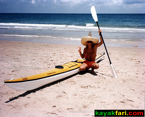
Today’s lightweight high-end boats present a new level of ergonomics and possibilities for personal freedom of movement. Distances of 20 to 30 miles in a day trip are totally doable with dialed-in equipment and proper paddling technique. The equipment means having the right fitting boat, not too tippy but not too big either (wide / volume). In that boat, finding the right position for the foot plate will allow for the best leg drive configuration. Then finding the wing paddle shape, size and length optimally fit for your setup would be the last step. However a Greenland stick, particularly one of the thin-edged carbon fiber ones, can also work very well. The “stick” and the “wing” can be thought of as complimentary, as they both work on the same principle. This is called “lift”, but unlike an aero foil, in this case the lift is generated horizontally to provide propulsion.
One can think of wing paddles and Greenland type paddles as a kind of propeller. With each particular wing paddle design, there is a set pitch, cant, twist and other parameters. The optimal motion is then wholly repetitive and should be as consistent as conditions allow. On flat water, where no other factors are at play, this motion can be achieved, practiced and maintained by elite paddlers. When you see these paddlers during the Olympics they often do look very machine like in motion! Surfski paddling on choppy or ocean waters calls for variations in the stroke as well as weight transfer to maintain balance and posture. With the Greenland stick however, there are many more variations available with each stroke. It’s completely possible to vary many of the parameters in mid-stroke such as the “pitch”, the depth (surface area) and angle as you paddle. Additionally, you can also throw in the sliding stroke – where you can generate some serious lift. This can be comparable to a wing paddle stroke in power, but still different. So the Greenland stick is actually an extremely versatile tool for paddling! (This is not even mentioning all the possibilities for “Greenland Kayaking” and rolling – a whole another ball game altogether.)
But why the waddle, you ask?
Similar to the way a Penguin waddles along on land, having your hips loose and able to move fore and aft in your seat is key. This is because your hips aren’t just for balance, they allow you to “drive” and direct your boat forward. This hip action is sometimes called “butt walking”. To get the full benefit, a kayak or surfski with a solid foot plate is needed. Then you can utilize foot and leg drive to push off this plate. Your knees will be close together as you move your hips and wind up your core to get the most out of each stroke. The ability of your hips to waddle in the seat allows the rest of your body to achieve more rotation and thus put more power into each stroke. Speed is built up incrementally and when you perfectly synch your leg drive with your stroke you will notice it!
So yes,
“it is OK to waddle inside your kayak”
if you want to go fast.
The right paddling technique relies on the dialed-in equipment mentioned above, but variations of even very basic gear can still provide some benefits. For instance you can certainly paddle most any kayak with a Greenland stick or wing paddle. Actually this can be a great way to learn the feel of the new paddle(s) with your current kayak. However, eventually one finds the right gear that works well together with their physiology and physical constraints. It’s at this phase that attention to proper technique can really come into play and provide real benefits. It does take continuous practice and is somewhat similar the martial arts in that it is a never ending process of improvement. This is especially important with skinny boats like the SES which need to be paddled at least once a week just to maintain a certain performance level. Then there comes the zen moment when everything falls together just right, and puts you into the zone. This is the moment all active paddlers strive for!
Shapes of things to come!
But I didn’t just set out to paddle a Penguin shaped loop, I also timed my trip to partially coincide with another one put on by the South Florida Paddlers group. The organizers of which scheduled a casual paddling trip to Stiltsville for novices or those who have never seen this famous Miami landmark (watermark). As this group started at the kayak launch inside Bills Baggs State Park, I was able to estimate a rendezvous time at the Stitlsville Village. Therefore I planned my launch next to the Miami Seaquarium to paddle the roughly six miles down there and meet up with the group. My timing was good, averaging about 6 mph and after maybe another 15 minutes of waiting, I saw the group of 30+ SUP and kayak paddlers appear on the horizon. The group provides a way for paddlers to experience the freedom and joy of being out on Biscayne Bay in a safe group setting. It takes several volunteers to manage a group of this size and they are well equipped to do it. Kudos to the group organizers for what a great job they do to bring out people fairly new to paddling, especially those to open water cruising. What an exciting introduction to a community of paddlers!
After touring Stiltsville and hanging out with the group for a while, I departed to finish the remainder of my own 22 mile trip. My wing paddle of choice on this trip was the Orka Super Flex blade which is a super smooth paddle that is really just a joy to paddle with. It’s a mid sized blade of 730 cm square and a variant of the “Gamma” shape. It is well built, if slightly heavier than more well known brands. It works well for sprinting or all day cruising without overtaxing me. In addition, I had my new carbon Greenland stick paddle to test out as well! This blade was a bit of an experiment in the purchase, but with free returns I figured I couldn’t loose. As it turns out it was a good gamble and I finished the last several of the 22 miles with it. Paddling a surfski with a Greenland stick is not often seen, but it can work – especially to learn the stability characteristics as I initially did six years ago with my SES. This new carbon stick has very thin edges which really make a difference and make for a nicer catch. This is now my favorite paddling combination with CANDY-O, my Stellar SILV sea kayak.
Look for more in depth exploration of wings, sticks and beautiful boats in the near future!
All original photographs, artworks and music in this portfolio are copyrighted and owned by the artist, Flex Maslan, unless otherwise noted. Any reproduction, modification, publication, transmission, transfer, or exploitation of any of the content, for personal or commercial use, whether in whole or in part, without written permission from the artist is strictly prohibited.
All rights reserved!
…
DISCLAIMER:
The maps and images on this site are not intended for navigation, I am not a guide; use any and all information at your own risk! Your mileage may vary .. so use good judgement before venturing out!
…
I hereby disclaim any sponsorship, endorsement, nor association with any product or service described herein. The photographs, depictions, products, and ideas presented on this site are for informational purposes only. Your results may vary, and I do not imply nor guarantee the effectiveness, suitability, design or operation to adhere to any standard. I assume no legal responsibility for the implementation of anything herein presented! Use any and all information at your own risk! By using any and all information from this website, you accept the final liability for any use or possible associated misuse!
“Conch Lives Matter!” Repatriating washed up Queen Conchs back into the sea! Hurricane Irma aftermath at Dania Beach and Mizell Johnson (John U Lloyd) State Park
.
South Florida experienced the wrath of hurricane Irma on September 9 to 11, 2017. The huge storm made a last minute shift to the west which meant that the east coast was spared it’s full fury. It was a very, very close call for us.
Not surprisingly, there weren’t many boaters out, just mostly tugs and freighters doing their jobs.
The maps and images on this site are not intended for navigation, I am not a guide; use any and all information at your own risk! Your mileage may vary .. so use good judgement before venturing out!
…
I hereby disclaim any sponsorship, endorsement, nor association with any product or service described herein. The photographs, depictions, products, and ideas presented on this site are for informational purposes only. Your results may vary, and I do not imply nor guarantee the effectiveness, suitability, design or operation to adhere to any standard. I assume no legal responsibility for the implementation of anything herein presented! Use any and all information at your own risk! By using any and all information from this website, you accept the final liability for any use or possible associated misuse!
This is a work of fiction. All characters appearing in this work are fictitious. Any resemblance to real persons, living or dead, is purely intentional. No skeleton, nor person, nor kayak was harmed in the making of this work. The author is sorely responsible for the contents of this work!
.
The maps and images on this site are not intended for navigation, I am not a guide; use any and all information at your own risk! Your mileage may vary .. so use good judgement before venturing out!
…
I hereby disclaim any sponsorship, endorsement, nor association with any product or service described herein. The photographs, depictions, products, and ideas presented on this site are for informational purposes only. Your results may vary, and I do not imply nor guarantee the effectiveness, suitability, design or operation to adhere to any standard. I assume no legal responsibility for the implementation of anything herein presented! Use any and all information at your own risk! By using any and all information from this website, you accept the final liability for any use or possible associated misuse!
The hungry ghost of a gator snaps at inquisitive paddlers. Halloween on the Taylor Slough.
.
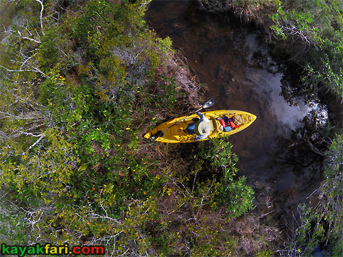
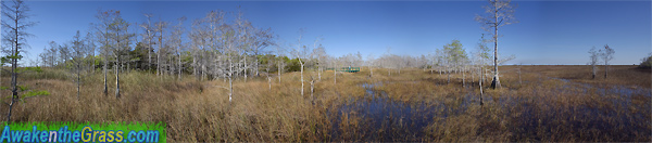
Grass paddling is a local Everglades specialty!
While free ranging is always possible, it’s usually best to save the energy by mostly sticking to (relatively) well established canoe and NPS airboat trails as much as possible. Poling, pushing, and paddling – it’s all good on the slough. This Halloween trip followed down the Taylor Slough and then the Craighead Pond Canoe Trail, eventually exiting at the Nine Mile Pond Canoe Trail. The upper part of Taylor Slough is a beautiful area, paddling amongst Cypress trees with mixed vegetation. Then the further south we went, the more open and prairie-like the landscape became. We kept moving across this wide open watery landscape until again being corralled into channels by coastal mangroves.
Then we ran out of daylight and it got real dark ..
The maps and images on this site are not intended for navigation, I am not a guide; use any and all information at your own risk! Your mileage may vary .. so use good judgement before venturing out!
…
I hereby disclaim any sponsorship, endorsement, nor association with any product or service described herein. The photographs, depictions, products, and ideas presented on this site are for informational purposes only. Your results may vary, and I do not imply nor guarantee the effectiveness, suitability, design or operation to adhere to any standard. I assume no legal responsibility for the implementation of anything herein presented! Use any and all information at your own risk! By using any and all information from this website, you accept the final liability for any use or possible associated misuse!
This is a work of fiction. All characters appearing in this work are fictitious. Any resemblance to real persons, living or dead, is purely intentional. No skeleton, nor person, nor kayak was harmed in the making of this work. The author is sorely responsible for the contents of this work!
The maps and images on this site are not intended for navigation, I am not a guide; use any and all information at your own risk! Your mileage may vary .. so use good judgement before venturing out!
…
I hereby disclaim any sponsorship, endorsement, nor association with any product or service described herein. The photographs, depictions, products, and ideas presented on this site are for informational purposes only. Your results may vary, and I do not imply nor guarantee the effectiveness, suitability, design or operation to adhere to any standard. I assume no legal responsibility for the implementation of anything herein presented! Use any and all information at your own risk! By using any and all information from this website, you accept the final liability for any use or possible associated misuse!
It was so bloody hot that we couldn’t even count straight anymore. Everglades hot summer camping and cruising – the Central & Western Florida Bay loop!
.
Florida Bay is a special kind of place to get away
from it all but come prepared to keep the party polite.
.
Summer in South Florida is the wet and rainy season and tends to be very hot! For paddlers the extreme heat and humidity can be risk factors for those unprepared. On any summer trip, it is essential to have up to twice the amount of drinking water that you think you need! This means ideally you should have up to 2 gallons (8 liters) of water per day. Most of us living in South Florida are habituated to the comfort of air conditioning, and it’s very easy to underestimate how much water you can sweat out!
Also there is the ever present possibility of afternoon squalls and violent thunderstorms. This is really the main wildcard to deal with, although even in the summer the storms or lack there-of tend to come in batches. With keen observation, it is possible to find a window for camping and avoid storms. For one or two night trips, the odds can be good. However if you stay out long enough, the odds will eventually catch up, as we shall see!
You can read more about dealing with the summer heat in:
The maps and images on this site are not intended for navigation, I am not a guide; use any and all information at your own risk! Your mileage may vary .. so use good judgement before venturing out!
…
I hereby disclaim any sponsorship, endorsement, nor association with any product or service described herein. The photographs, depictions, products, and ideas presented on this site are for informational purposes only. Your results may vary, and I do not imply nor guarantee the effectiveness, suitability, design or operation to adhere to any standard. I assume no legal responsibility for the implementation of anything herein presented! Use any and all information at your own risk! By using any and all information from this website, you accept the final liability for any use or possible associated misuse!
The Sweetwater chickee camping platform was next on our list. It lies tucked away inside a little ‘finger cove’ of Sweetwater Bay. It is also pretty close to the Everglades interior (i.e. the slough) so the tidal influence was minimal here. I tasted the water and it was pretty sweet, probably good enough to filter. However this may not always be the case at other times of the year!
(tap or click pic to read)
The Sweetwater chickee is aptly named for the water was indeed sweeter! Heaven or Hell: Summer paddling and camping in the Ten Thousand Islands
.
Paddling in the summer heat really feels like being in a steam bath. I tried dunking myself in the water to cool off, but it was not very effective since the water felt like a hot tub. Still, the evaporation of the water did help a tiny bit. I was glad that I used an old somewhat leaky nylon spray skirt rather than my neoprene nice fitting one. The porousness did keep me cooler!
Some people bring sports drinks for hydration. I rely mostly on plain water supplemented with rations of young cocoanut water to replenish the sweated out salts. If you go paddling in the summer, it bears repeating:
Bring twice the amount of drinking water you think you’ll need!
The maps and images on this site are not intended for navigation, I am not a guide; use any and all information at your own risk! Your mileage may vary .. so use good judgement before venturing out!
…
I hereby disclaim any sponsorship, endorsement, nor association with any product or service described herein. The photographs, depictions, products, and ideas presented on this site are for informational purposes only. Your results may vary, and I do not imply nor guarantee the effectiveness, suitability, design or operation to adhere to any standard. I assume no legal responsibility for the implementation of anything herein presented! Use any and all information at your own risk! By using any and all information from this website, you accept the final liability for any use or possible associated misuse!
Do what you must to establish solid footing in your boat .. Your feet are the key to proper paddling posture!
.
Being mindful of your feet as the foundation for your paddling posture will yield many benefits over time!
Many paddlers don’t seem to think much about their feet unless they happen to step wrong on something. The focus always seems to be more on their arms, their hips and their paddles. But the foot is an important and integral part of kayaking and all paddling in general. Along with the hips and thighs, the feet position a paddler in or on top of their craft and provide an anchor point for optimum paddling motion.
The maps and images on this site are not intended for navigation, I am not a guide; use any and all information at your own risk! Your mileage may vary .. so use good judgement before venturing out!
…
I hereby disclaim any sponsorship, endorsement, nor association with any product or service described herein. The photographs, depictions, products, and ideas presented on this site are for informational purposes only. Your results may vary, and I do not imply nor guarantee the effectiveness, suitability, design or operation to adhere to any standard. I assume no legal responsibility for the implementation of anything herein presented! Use any and all information at your own risk! By using any and all information from this website, you accept the final liability for any use or possible associated misuse!
One of the two tall Florida Bay chickee platforms – at Johnson Key. Everglades hot summer camping and cruising – the Central & Western Florida Bay loop!
.
Once out past the first line of keys outside Flamingo,
it’s sometimes possible to go for days without
hearing any background noises whatsoever!
🙂
When sounds do happen it’s usually a plane high overhead or a boater somewhere in the distance and fades away quickly. So even though Florida Bay is surrounded by a busy world of people, once inside it’s like a step back into time. It’s easy to imagine what the string of Florida Keys must have been like before all the islands were connected by bridges.
The maps and images on this site are not intended for navigation, I am not a guide; use any and all information at your own risk! Your mileage may vary .. so use good judgement before venturing out!
…
I hereby disclaim any sponsorship, endorsement, nor association with any product or service described herein. The photographs, depictions, products, and ideas presented on this site are for informational purposes only. Your results may vary, and I do not imply nor guarantee the effectiveness, suitability, design or operation to adhere to any standard. I assume no legal responsibility for the implementation of anything herein presented! Use any and all information at your own risk! By using any and all information from this website, you accept the final liability for any use or possible associated misuse!
Paddling just as easy as 1 – 2 – 3 ? Perhaps, or perhaps not! Escape from Babylon into the Ten Thousand Islands.
.
This trip added up to about 84 miles with a nice progression
of 11, 20, 25 and 28 mile days.
A memorable escape into the the Ten Thousand Islands of the Everglades!
The Ten Thousands Islands of southwest Florida have a rich human history that dates back thousands of years. For instance, the Calusa Native Americans prospered here, living off the bounty of the coastal marine zone. Rare in human history, they achieved an advanced level of civilization that was not centered on agriculture. They also left us plenty of evidence of just how much, and how well they ate in the form the “midden mounds”. These are basically garbage heaps, of mostly shells, some reaching very large proportions! The remoteness and isolation of the 10K attracted white settlers in the last 150 years to eek out a living, often on top of those old Calusa shell mounds. Some of the so called settlers were actually seeking a place to escape to, to evade the law, perhaps permanently.
In more recent times, access to the 10000 Islands has become codified with the creation of Everglades National Park and other wildlife sanctuaries. Conveniently spaced campsites which can be “reserved” months ahead of time serve to give a familiar structure to an otherwise wild place. A few people still make a living out there, mostly to get others in and out and help them get the most out of the area.
Still, there are a few hidden gems left where the original story continues!
The maps and images on this site are not intended for navigation, I am not a guide; use any and all information at your own risk! Your mileage may vary .. so use good judgement before venturing out!
…
I hereby disclaim any sponsorship, endorsement, nor association with any product or service described herein. The photographs, depictions, products, and ideas presented on this site are for informational purposes only. Your results may vary, and I do not imply nor guarantee the effectiveness, suitability, design or operation to adhere to any standard. I assume no legal responsibility for the implementation of anything herein presented! Use any and all information at your own risk! By using any and all information from this website, you accept the final liability for any use or possible associated misuse!
“Mount Dania” towers over the beach at Dr. Von D. Mizell-Eula Johnson State Park. The shifting sands of time – Beach erosion and re-nourishments in Dania Beach.
With the Grand Opening of Mount Dania, Florida State Park planners
have revealed a new strategy designed to combat beach erosion!
The planners have announced that it is estimated that leaving the sand in this form will allow it to last up to 5x longer than if it was distributed over the beach. The sand has been trucked in from large sand deposit pits near Lake Okeechobee, and about 22,222 loads were needed to build this monumental project.
Additionally, some new beach activities will be allowed. These include the kayak slide, sand rolling, sand boarding, uphill kiting and downhill sand ski racing, among others. However once a beach umbrella has been planted at the top, that visitor shall be allowed to claim the mountain for one hour!
So hurry on over to Dania Beach – today is your first chance to claim your mountain!
The maps and images on this site are not intended for navigation, I am not a guide; use any and all information at your own risk! Your mileage may vary .. so use good judgement before venturing out!
…
I hereby disclaim any sponsorship, endorsement, nor association with any product or service described herein. The photographs, depictions, products, and ideas presented on this site are for informational purposes only. Your results may vary, and I do not imply nor guarantee the effectiveness, suitability, design or operation to adhere to any standard. I assume no legal responsibility for the implementation of anything herein presented! Use any and all information at your own risk! By using any and all information from this website, you accept the final liability for any use or possible associated misuse!
Under the serious Moonlight in the Ten Thousand Islands. ART of Darkness – Camping with the Stars! Part I
.
The moon’s steady ascent above the horizon is clear evidence of an endless cosmic cycle. From day to night, month to month, epoch to epoch – as our little planet world moves through space and time.
Camping with the Stars means going outside to experience the night as all the wild creatures of the earth do, or as closely as modern western society humans can. It is to step away from, and to go outside the world of people. It means to look up at the vast infinity above full of billions and billions of stars and feel humbled. It means to connect with the power of the infinite and transcend our daily, busy modern lives. It also means to stay up close and connected to the rhythms of the heavens and of the earth!
The maps and images on this site are not intended for navigation, I am not a guide; use any and all information at your own risk! Your mileage may vary .. so use good judgement before venturing out!
…
I hereby disclaim any sponsorship, endorsement, nor association with any product or service described herein. The photographs, depictions, products, and ideas presented on this site are for informational purposes only. Your results may vary, and I do not imply nor guarantee the effectiveness, suitability, design or operation to adhere to any standard. I assume no legal responsibility for the implementation of anything herein presented! Use any and all information at your own risk! By using any and all information from this website, you accept the final liability for any use or possible associated misuse!
Wet surfski workout session paddling through Port Everglades in Ft Lauderdale. Paddling in the Rain, Just Paddlin’ and Campin’ in the Rain .. sing along!
The maps and images on this site are not intended for navigation, I am not a guide; use any and all information at your own risk! Your mileage may vary .. so use good judgement before venturing out!
…
I hereby disclaim any sponsorship, endorsement, nor association with any product or service described herein. The photographs, depictions, products, and ideas presented on this site are for informational purposes only. Your results may vary, and I do not imply nor guarantee the effectiveness, suitability, design or operation to adhere to any standard. I assume no legal responsibility for the implementation of anything herein presented! Use any and all information at your own risk! By using any and all information from this website, you accept the final liability for any use or possible associated misuse!
The “Widowmaker” meant pushing, pulling or throwing boats over mangroves as necessary! Crossing paths of Gladesmen, Gator hunters, Outlaws and Moonshiners: An invitation to paddling forgotten trails of the Everglades!
.
The Bill Ashley Jungles is an area west of the main Park road roughly between Paurotis Pond and Hell’s Bay, and we were right in the middle of it! Historically these were productive hunting grounds for both Native American tribes and later “Cracker” gator hunters and trappers. This landscape has also changed over the decades, with brackish water intruding northwards, resulting in the predominantly wet mangrove forest habitat that we saw. It certainly did not look like it to us, but back in the 1920′-30’s there was abundant game deer to be had here! Today this is a largely forgotten area, except for the Hell’s Bay Canoe Trail that runs through a part of it. This single trail probably the single most popular paddling route inside of Everglades National Park.
Paradoxically this area is at once the most visited,
yet also the least explored!
The Bill Ashley Jungles were named after a band of outlaws who hid out in the Glades in the 1910’s-20’s called the Ashley Gang, led by John Ashley and his “queen”, Laura Upthegrove. Back then almost everything in South Florida was still the “Everglades”, so whether you were in Homestead or Jupiter, you’d still be in the “Everglades”. It was more of a question of how hard it was to get in and out. By 1924 members of the close knit Ashley Gang family were either in custody or dead. Bill Ashley, one of John’s brothers was apprehended in January 1924, and was the only one who actually survived the family “business” and then lived out his years in Pompano Beach until his death in 1940.
The maps and images on this site are not intended for navigation, I am not a guide; use any and all information at your own risk! Your mileage may vary .. so use good judgement before venturing out!
…
I hereby disclaim any sponsorship, endorsement, nor association with any product or service described herein. The photographs, depictions, products, and ideas presented on this site are for informational purposes only. Your results may vary, and I do not imply nor guarantee the effectiveness, suitability, design or operation to adhere to any standard. I assume no legal responsibility for the implementation of anything herein presented! Use any and all information at your own risk! By using any and all information from this website, you accept the final liability for any use or possible associated misuse!
This simple laminated Google Earth printout sufficed for maybe 90% of my navigational needs. (For the remaining 10% I thanked Ted’s GPS unit.) Escape from Babylon into the Ten Thousand Islands.
.
The Ten Thousands Islands of southwest Florida have a rich human history that dates back thousands of years. The Calusa Native Americans prospered here, living off the bounty of the coastal marine zone. Rare in human history, they achieved an advanced level of civilization that was not based on agriculture! They left plenty of evidence of just how much (and how well) they ate in the form the “midden mounds”. These are basically garbage heaps, of mostly shells, some quite large! The remoteness and isolation of the 10K attracted white settlers in the last 150 years to eek out a living, often on top of the old Calusa shell mounds. Some of the so called settlers were actually seeking a place to escape to, perhaps permanently.
In the modern era, we can also strive to escape,
if only for a limited time!
With my paddling partner Kayak Ted, we hatched yet another route plan to take us further south along the Ten Thousand Islands coastline and then visit a few interior campsites on the Wilderness Waterway. One of best things about tripping with Ted is that he’s down with (some of) my oddball suggestions, and sometimes he pulls out one of his own.
Such as, let’s start our 3 night trip at 5pm, day of!
In the end we paddled about 84 miles and had a nice progression of 11, 20, 25 and 28 mile days. The conditions were mostly favorable, the bugs weren’t that bad on this adventure, and it was a great trip in the Ten Thousand Islands.
A fun escape from Babylon into the Everglades outback!
The maps and images on this site are not intended for navigation, I am not a guide; use any and all information at your own risk! Your mileage may vary .. so use good judgement before venturing out!
…
I hereby disclaim any sponsorship, endorsement, nor association with any product or service described herein. The photographs, depictions, products, and ideas presented on this site are for informational purposes only. Your results may vary, and I do not imply nor guarantee the effectiveness, suitability, design or operation to adhere to any standard. I assume no legal responsibility for the implementation of anything herein presented! Use any and all information at your own risk! By using any and all information from this website, you accept the final liability for any use or possible associated misuse!
Miami adventurer Leah stands up in her sea kayak and surveys the sea of grass. Grass Paddling in the East Everglades Expansion Area – History, Gladesmen & more Grass!
.
The airboater was quite surprised to see a bunch of canoeists and kayakers already there at the dock, including (then) Everglades National Park Superintendent Dan Kimball!
Out on this sea of grass, it’s important to be able to stand up and see over all the tall grass! This is easy in a canoe, but much harder in a narrow sea kayak. Fortunately, the shallow depth and extensive vegetation cradle the hull and make this easier. Using the paddle as a support pole also helps.
The biggest challenge to paddling a long sea kayak in the grass is that you have to pick your line exactly and stick with it! The long kayak acts a lot like a knife blade – easy to push through the vegetation, but nearly impossible to turn sideways from a dead stop. It really helps to keep constantly moving, and you need to edge the boat because the rudder or rudder strokes are useless and unworkable in the grass. The few times I got off track I had to back up like a semi truck (beep beep .. beep beep) and start my line up again!
The maps and images on this site are not intended for navigation, I am not a guide; use any and all information at your own risk! Your mileage may vary .. so use good judgement before venturing out!
…
I hereby disclaim any sponsorship, endorsement, nor association with any product or service described herein. The photographs, depictions, products, and ideas presented on this site are for informational purposes only. Your results may vary, and I do not imply nor guarantee the effectiveness, suitability, design or operation to adhere to any standard. I assume no legal responsibility for the implementation of anything herein presented! Use any and all information at your own risk! By using any and all information from this website, you accept the final liability for any use or possible associated misuse!
Good evening universe! The super full moon camping experience at Little Rabbit Key, now with Sunspots.
.
The particular full moon in this story was a once or twice in a lifetime experience. The supermoon appeared 14% larger and 30% brighter than usual as it was closest to the Earth since 1948. Moreover, the next really impressive supermoon like this one won’t occur until 2034!
However it doesn’t have to be a supermoon to experience
the magic of a full moon night!
To fully appreciate full moon camping it is worthwhile to paddle out to one of the more remote backcountry campsites in the Everglades. This story starts by paddling out to Little Rabbit Key which is centrally located in Florida Bay.
The SMC Pentax 1000mm reflex lens really makes photographing the moon and the sun worthwhile, especially with an APS-C sensor cam. Getting focus spot on can be tricky, but the reflex design really shines in this application. Note that a special solar filter must be installed over the lens to prevent permanent damage to eyes and sensors! It’s called a Baader safety film and made of a coated mylar. When paired with the versatile Pentax Q camera, I can image at a 5600mm equivalent reach of the moon or the sun.
The maps and images on this site are not intended for navigation, I am not a guide; use any and all information at your own risk! Your mileage may vary .. so use good judgement before venturing out!
…
I hereby disclaim any sponsorship, endorsement, nor association with any product or service described herein. The photographs, depictions, products, and ideas presented on this site are for informational purposes only. Your results may vary, and I do not imply nor guarantee the effectiveness, suitability, design or operation to adhere to any standard. I assume no legal responsibility for the implementation of anything herein presented! Use any and all information at your own risk! By using any and all information from this website, you accept the final liability for any use or possible associated misuse!
Due to time constraints, it took place over the Labor Day weekend just ahead of approaching tropical storm Gordon. The plan me and Kayak Ted (aka Spiritwalker) made was to camp at North Nest Key and use it as a base camp for two nights. Joe Bay is intriguing because it has been re-opened to the public after being closed off for almost 40 years. It is also prime habitat for the American Crocodile, of which we had hoped to see many.
However as the saying goes
“The best laid plans of photographers and paddlers often go awry”
especially when a big storm rolls through early!
.
(tap or click pic to read)
When a big storm blows through, Plan B happens! North Nest Key, Joe Bay and tropical storm Gordon.
.
North Nest Key is not the place to go if you seek solitude,
however it’s worth a visit and makes a great base camp location
The evening and most of the night were pleasant camping, but by dawn it was clear that things had changed. Getting up with the sunrise, there was a lot of cloud cover and a heavy damp feeling in the air. Listening to the weather radio and checking radar on the phone we could see that tropical storm Gordon had arrived into our area earlier than anticipated. By 8:30, we were already seeing lightning strikes to the NE in the distance which was definitely not a good sign! We had to make a decision, and both agreed that in light of our situation we’d bag it and head back a day early. We packed up camp just in time before all the heavy rain hit. At times it rained so hard, that we couldn’t even see each other on the water.
The maps and images on this site are not intended for navigation, I am not a guide; use any and all information at your own risk! Your mileage may vary .. so use good judgement before venturing out!
…
I hereby disclaim any sponsorship, endorsement, nor association with any product or service described herein. The photographs, depictions, products, and ideas presented on this site are for informational purposes only. Your results may vary, and I do not imply nor guarantee the effectiveness, suitability, design or operation to adhere to any standard. I assume no legal responsibility for the implementation of anything herein presented! Use any and all information at your own risk! By using any and all information from this website, you accept the final liability for any use or possible associated misuse!
Represent! Flying the colors at the launch in Everglades City. Moonshine in the 10 000 Islands of the Everglades.
.
A simple “overnight” trip,
but with about 42 miles to cover.
On offer in this story is a photo journey of a quest to find a “lost” bit of old Everglades history. It’s the story of a Prohibition era liquor still hidden deep in the mangrove jungles of the Ten Thousand Islands.
It takes us back to the beginnings of the fascinating life story of Chokoloskee resident Loren “Totch” Brown who lived there. If you are not familiar, his book is a must read:
With the Liquor Still Bay mission accomplished, we headed out into the Gulf on a slack tide. The paddling was easy and serene, and not at all what the Gulf waters would have waiting in store for us.
The maps and images on this site are not intended for navigation, I am not a guide; use any and all information at your own risk! Your mileage may vary .. so use good judgement before venturing out!
…
I hereby disclaim any sponsorship, endorsement, nor association with any product or service described herein. The photographs, depictions, products, and ideas presented on this site are for informational purposes only. Your results may vary, and I do not imply nor guarantee the effectiveness, suitability, design or operation to adhere to any standard. I assume no legal responsibility for the implementation of anything herein presented! Use any and all information at your own risk! By using any and all information from this website, you accept the final liability for any use or possible associated misuse!
Emerging from the refuge of the micro-tent / cage after 12+ hours. Camping Hell in the Ten Thousand Islands.
.
Revised and updated for your reading pleasure!
Starting with a late departure, this trip seemed all about pushing our luck. It was a 3 day and 3 night kinda trip, if that makes any sense? The idea was to revisit the liquor still in the Everglades we had found earlier, and also see a bunch of places en route. We explored the Gopher Key Calusa mound and then rode Charley Creek out into the Gulf of Mexico, followed by camping at Pavilion Key.
Thanks to skill, perseverance and some luck we were able to visit
all the spots as planned, however the camping was just plain ugly!!
The maps and images on this site are not intended for navigation, I am not a guide; use any and all information at your own risk! Your mileage may vary .. so use good judgement before venturing out!
…
I hereby disclaim any sponsorship, endorsement, nor association with any product or service described herein. The photographs, depictions, products, and ideas presented on this site are for informational purposes only. Your results may vary, and I do not imply nor guarantee the effectiveness, suitability, design or operation to adhere to any standard. I assume no legal responsibility for the implementation of anything herein presented! Use any and all information at your own risk! By using any and all information from this website, you accept the final liability for any use or possible associated misuse!
I began to dress like them to fit in, and soon they began to accept me as one of their own. ART of Cape Romano – The curious inhabitants of Australopithecine Island.
.
On a remote island in the Ten Thousand Islands area of the Everglades an isolated tribe of curious Australopithecines took up residence in the Cape Romano dome ruins. For years the clan lived in harmony subsisting on a diet of mostly fish, marine life and herbs. Sometimes they would find ready made food containers with half eaten sandwiches and salads, presumably left behind by the “hairless ones” (whom we call tourists).
These were “feast” days to them, and the living was good!
The hominins soon learned that the “hairless ones” would come twice a day, morning and afternoon, almost like the movement of tides. They would watch from their hiding places and later find other objects the “hairless” sometimes left behind. They made good use of all the things left to them like tents, tarps and plastic cups and wood pieces!
The first Australopithecine I ever met, I named him “George” due to his curious nature! There was also at least one female of breeding age and I called her “Lucy”, along with a young juvenile male “Diego”. Where in the world did he come from?
The maps and images on this site are not intended for navigation, I am not a guide; use any and all information at your own risk! Your mileage may vary .. so use good judgement before venturing out!
…
I hereby disclaim any sponsorship, endorsement, nor association with any product or service described herein. The photographs, depictions, products, and ideas presented on this site are for informational purposes only. Your results may vary, and I do not imply nor guarantee the effectiveness, suitability, design or operation to adhere to any standard. I assume no legal responsibility for the implementation of anything herein presented! Use any and all information at your own risk! By using any and all information from this website, you accept the final liability for any use or possible associated misuse!
At the end of 2021, Dr. Von D. Mizell-Eula Johnson State Park is a construction zone! The shifting sands of time – Beach erosion and re-nourishments in Dania Beach.
The maps and images on this site are not intended for navigation, I am not a guide; use any and all information at your own risk! Your mileage may vary .. so use good judgement before venturing out!
…
I hereby disclaim any sponsorship, endorsement, nor association with any product or service described herein. The photographs, depictions, products, and ideas presented on this site are for informational purposes only. Your results may vary, and I do not imply nor guarantee the effectiveness, suitability, design or operation to adhere to any standard. I assume no legal responsibility for the implementation of anything herein presented! Use any and all information at your own risk! By using any and all information from this website, you accept the final liability for any use or possible associated misuse!
Pedal and Paddle at Shark Valley: The kayak and the wheel, a symbiotic relationship. Kayaking at Shark Valley – A visit to Seagrape Hammock, aka Willoughby Key!
.
The lunatics are on the Grass,
Got to keep those loonies off the trail!
.
Everglades exploration and photography in the style of the classic1898 book “Across the Everglades“, by Hugh L. Willoughby.
This is a story of a “pedal and paddle” visit to a small tree island hammock in the Everglades “River of Grass”. We used bicycles, a trailer and a tandem SOT kayak to ride down the tram road and paddle through the grass to the island. The Shark Valley tower happens to be only a short distance from this tree island called “Seagrape Hammock” in the middle of the Shark River Slough. Hugh L. Willoughby wrote about the island in his classic 1898 book – “Across the Everglades” and dubbed it “Willoughby Key”. He kept excellent records and published the accurate coordinates in his book, so we know for a fact that it is Seagrape Hammock.
He actually liked this island so much that he camped there twice!
Why go to Seagrape Hammock? Well there’s the historical connection already mentioned that gives us a window into the Everglades of old circa 1898. At that time, the Everglades were largely still untouched and pristine. The Seminole Native Americans were still able to live a largely traditional subsistence way of life. The Everglades were clean, bountiful and unfettered. However within a generation afterwards, the irreversible system wide alterations and damage to the Everglades ecosystem would begin. So Willoughby’s descriptions are among the last of the real Everglades as they had existed for millennia prior!
I had been fascinated with this tree island ever since sighting it during a trip down the Shark River slough in 2012. But on that trip we passed close within a mile, although couldn’t take the time for the detour. On this trip we succeeded and I had plenty of time to explore and photograph the Seagrape Hammock tree island!
Geographically, Seagrape Hammock is situated roughly halfway in between the Cypress strands of Big Cypress to the west and the higher (now developed) Pineland ridge to the east.
The maps and images on this site are not intended for navigation, I am not a guide; use any and all information at your own risk! Your mileage may vary .. so use good judgement before venturing out!
…
I hereby disclaim any sponsorship, endorsement, nor association with any product or service described herein. The photographs, depictions, products, and ideas presented on this site are for informational purposes only. Your results may vary, and I do not imply nor guarantee the effectiveness, suitability, design or operation to adhere to any standard. I assume no legal responsibility for the implementation of anything herein presented! Use any and all information at your own risk! By using any and all information from this website, you accept the final liability for any use or possible associated misuse!
Don’t stop, don’t stop – The Rabbit in the Moon in Florida. ART of Darkness – Camping with the Stars! Part I
.
Staring at the moon can be a hypnotic experience, yet many creatures are nocturnal. They live and die under the moonlight. I once saw a whole flock of Pelicans gliding in the breezes above me in the moonlight. They flew silently in formations, with only the swoosh of their wings giving them away! The moon’s gravitational pull works ocean tides in an endless cycle. In the Everglades this is particularly apparent, especially in places like the flats of First National Bank in the western part of Florida Bay!
The maps and images on this site are not intended for navigation, I am not a guide; use any and all information at your own risk! Your mileage may vary .. so use good judgement before venturing out!
…
I hereby disclaim any sponsorship, endorsement, nor association with any product or service described herein. The photographs, depictions, products, and ideas presented on this site are for informational purposes only. Your results may vary, and I do not imply nor guarantee the effectiveness, suitability, design or operation to adhere to any standard. I assume no legal responsibility for the implementation of anything herein presented! Use any and all information at your own risk! By using any and all information from this website, you accept the final liability for any use or possible associated misuse!
Last rays of sunshine over the Cape Romano dome home ruins! Paddling the Goodland to Cape Romano loop and camping in the aftermath of Hurricane Irma.
.
Hurricane Irma made landfall directly at Cape Romano at about 3pm EST on Sunday, September 10, 2017 as a Category 3 storm. The 120 mph winds and strong storm surge collapsed two of the six dome home structures and further eroded the coastline. What was once a very wide and large sandy beach at the tip of the cape has been reduced to a tiny strip of sand.
Since the hurricane, there is even less beach left now, and the best camping is a little further north along the western shoreline.
The Goodland to Cape Romano paddling loop amounts to at least 14 miles, with much of it in open water on Gullivan Bay in the Ten Thousand Islands. However this can be a relatively easy paddle for intermediate level paddlers with several semi-sheltered route options depending on weather conditions. You can also hug the shoreline the whole way if you don’t like open water paddling, but it will make for a longer paddle. Evidence of the powerful hurricane can still be seen all along the coastline and the Morgan River.
The maps and images on this site are not intended for navigation, I am not a guide; use any and all information at your own risk! Your mileage may vary .. so use good judgement before venturing out!
…
I hereby disclaim any sponsorship, endorsement, nor association with any product or service described herein. The photographs, depictions, products, and ideas presented on this site are for informational purposes only. Your results may vary, and I do not imply nor guarantee the effectiveness, suitability, design or operation to adhere to any standard. I assume no legal responsibility for the implementation of anything herein presented! Use any and all information at your own risk! By using any and all information from this website, you accept the final liability for any use or possible associated misuse!
Watching my kayak slowly drift away from me on the flats of central Florida Bay. Across Florida Bay: Flamingo to Long Key Roundtrip Adventure!
.
Know where?
Nowhere and now here!
Across Florida Bay is about 25 – 30 miles each way, so it’s possible to do this roundtrip in two days. However, chances are you might get stranded on one of the flats banks because the tide models inverse about half way through to the Keys. Also, you might just miss out on all those little things along the way, so my advice is to ‘slow it down’ brothers and sisters!
You are truly in ‘the middle of nowhere’ out on Florida Bay!
The maps and images on this site are not intended for navigation, I am not a guide; use any and all information at your own risk! Your mileage may vary .. so use good judgement before venturing out!
…
I hereby disclaim any sponsorship, endorsement, nor association with any product or service described herein. The photographs, depictions, products, and ideas presented on this site are for informational purposes only. Your results may vary, and I do not imply nor guarantee the effectiveness, suitability, design or operation to adhere to any standard. I assume no legal responsibility for the implementation of anything herein presented! Use any and all information at your own risk! By using any and all information from this website, you accept the final liability for any use or possible associated misuse!
The neon day-glo airboat Mothership of the Everglades with kayaks! Grass paddling and poling in the Everglades Water Conservation Areas.
.
In the permanently flooded Water Conservation Areas of the Glades, the airboat is the best way to get around and reach fishing and hunting grounds and private camps. Still there is something very pure and beautiful being out on the water where it’s just you, the boat and your pole or paddle.
Moving through the landscape at a human pace can be hard work,
but can also be immensely satisfying for body, mind and soul!
Times are changing again for the Everglades, this time for the better. Let’s face it, people care most about the things they know and love. Additional human powered access whether on foot, boat or even bicycle can raise awareness and help drive Everglades Restoration efforts for generations forward!
The maps and images on this site are not intended for navigation, I am not a guide; use any and all information at your own risk! Your mileage may vary .. so use good judgement before venturing out!
…
I hereby disclaim any sponsorship, endorsement, nor association with any product or service described herein. The photographs, depictions, products, and ideas presented on this site are for informational purposes only. Your results may vary, and I do not imply nor guarantee the effectiveness, suitability, design or operation to adhere to any standard. I assume no legal responsibility for the implementation of anything herein presented! Use any and all information at your own risk! By using any and all information from this website, you accept the final liability for any use or possible associated misuse!
Buenos días from Camp LuLu beach on the Gulf coast of the Everglades. Camping at Camp LuLu in the Ten Thousand Islands.
.
Camp LuLu is a great place to camp and is popular with paddlers and powerboaters alike. Since it is outside Everglades National Park, no permit is needed, but you still need to respect the private property on the island, such as the green cabin! Excellent place to relax, has weathered deadwood to setup your hammock on. Also great for shelling and just walking along the beautiful sandy beaches.
Like many Gulf campsites beware the Raccoons as they sometimes work in teams! Also if you arrive at low tide, you’ll have several hundred feet of mudflats to explore or fish from. You may consider to bring some pool noodles to use as logs to roll your kayak onto the beach with, lest you get stuck in those mudflats!
The maps and images on this site are not intended for navigation, I am not a guide; use any and all information at your own risk! Your mileage may vary .. so use good judgement before venturing out!
…
I hereby disclaim any sponsorship, endorsement, nor association with any product or service described herein. The photographs, depictions, products, and ideas presented on this site are for informational purposes only. Your results may vary, and I do not imply nor guarantee the effectiveness, suitability, design or operation to adhere to any standard. I assume no legal responsibility for the implementation of anything herein presented! Use any and all information at your own risk! By using any and all information from this website, you accept the final liability for any use or possible associated misuse!
The event’s special guest was Daniella Levine Cava, the Mayor of Miami-Dade County. She and her husband Dr Rob Cava are both avid canoeists! Everglades Invitational 2021 on the Nine Mile – Craighead Pond route!
.
This year’s event was held in the Nine Mile Pond and Craighead Pond areas east of the Park road and just north of the mangrove forests that border Florida Bay. The Everglades Invitational 2021 Paddling Event was a success and we have resurrected a yearly Everglades tradition of sorts.
We paddled all day long, right into a glorious sunset!
The maps and images on this site are not intended for navigation, I am not a guide; use any and all information at your own risk! Your mileage may vary .. so use good judgement before venturing out!
…
I hereby disclaim any sponsorship, endorsement, nor association with any product or service described herein. The photographs, depictions, products, and ideas presented on this site are for informational purposes only. Your results may vary, and I do not imply nor guarantee the effectiveness, suitability, design or operation to adhere to any standard. I assume no legal responsibility for the implementation of anything herein presented! Use any and all information at your own risk! By using any and all information from this website, you accept the final liability for any use or possible associated misuse!
An outback plein air apartment on the creek. Gone up Crooked Creek to have a little chickee camping fun!
.
At about 9 miles out from the Park launch at Everglades City it sits between the Lopez River and Sunday Bay. The paddling distance is about the same whether you come up the Lopez River from the Gulf side or paddle inside via the Turner River.
The Crooked Creek chickee is well positioned as an easy
first night camp for many Ten Thousand Islands trips.
The maps and images on this site are not intended for navigation, I am not a guide; use any and all information at your own risk! Your mileage may vary .. so use good judgement before venturing out!
…
I hereby disclaim any sponsorship, endorsement, nor association with any product or service described herein. The photographs, depictions, products, and ideas presented on this site are for informational purposes only. Your results may vary, and I do not imply nor guarantee the effectiveness, suitability, design or operation to adhere to any standard. I assume no legal responsibility for the implementation of anything herein presented! Use any and all information at your own risk! By using any and all information from this website, you accept the final liability for any use or possible associated misuse!
This is some of the stickies, clingiest, and bottomless muck that there is! Barron Creek to Ferguson River Loop – Mangroves, Airboats and Mud.
.
That said, the area is beautiful, particularly the mangrove tunnels in the eastern section and the “prairie” zone just past that. The mangrove tunnels are possibly some of the most striking that you’ll find anywhere. This is why they run tourist airboat tours here. After this you’ll come into a cove with some of the stickiest, clingiest & bottomless quicksand / mud that there is!
If you capsize here for some reason .. well good luck! 😮
The maps and images on this site are not intended for navigation, I am not a guide; use any and all information at your own risk! Your mileage may vary .. so use good judgement before venturing out!
…
I hereby disclaim any sponsorship, endorsement, nor association with any product or service described herein. The photographs, depictions, products, and ideas presented on this site are for informational purposes only. Your results may vary, and I do not imply nor guarantee the effectiveness, suitability, design or operation to adhere to any standard. I assume no legal responsibility for the implementation of anything herein presented! Use any and all information at your own risk! By using any and all information from this website, you accept the final liability for any use or possible associated misuse!
Paddling down “Main Street” in the middle of Shark River Slough in the Everglades. Kayaking the River of Grass – a Shark River Slough Expedition.
.
Out here, you hear EVERYTHING! There is silence here, but more often than not, we would hear distant rumbles and the sounds of machines. Airboats from the “Everglades Ecotours” tourist rides just east and north of the park, the buzz of many small and private planes flying and training overhead .. airliners on final approach to MIA. The Shark River Slough feels remote, but is not nearly as quiet as the Taylor Slough.
Paddling in this upper section of the Park is true grass paddling, a seemingly endless realm of water and grass punctuated only by tree hammocks of various sizes. Many of the larger ones were used in the past by native Indian tribes, and later by Gladesmen as hunting camps, etc. On our route we came within just a few miles SE of the Shark Valley tower, and we could see it’s distinct shape in the distance.
On the critical section where we would come to intersect what is called “Main Street”, which is a well defined airboat trail that runs down the middle of the slough.
This trail would takes us all the way into Bottle Creek on the southern edge of the slough!
The maps and images on this site are not intended for navigation, I am not a guide; use any and all information at your own risk! Your mileage may vary .. so use good judgement before venturing out!
…
I hereby disclaim any sponsorship, endorsement, nor association with any product or service described herein. The photographs, depictions, products, and ideas presented on this site are for informational purposes only. Your results may vary, and I do not imply nor guarantee the effectiveness, suitability, design or operation to adhere to any standard. I assume no legal responsibility for the implementation of anything herein presented! Use any and all information at your own risk! By using any and all information from this website, you accept the final liability for any use or possible associated misuse!
Don’t let your feet get angry .. Your feet are the key to proper paddling posture!
.
Many paddlers don’t seem to think much about their feet unless they happen to step wrong on something. The focus always seems to be more on their arms, their hips and their paddles. But the foot is an important and integral part of kayaking and all paddling in general. Along with the hips and thighs, the feet position a paddler in or on top of their craft and provide an anchor point for optimum paddling motion.
The maps and images on this site are not intended for navigation, I am not a guide; use any and all information at your own risk! Your mileage may vary .. so use good judgement before venturing out!
…
I hereby disclaim any sponsorship, endorsement, nor association with any product or service described herein. The photographs, depictions, products, and ideas presented on this site are for informational purposes only. Your results may vary, and I do not imply nor guarantee the effectiveness, suitability, design or operation to adhere to any standard. I assume no legal responsibility for the implementation of anything herein presented! Use any and all information at your own risk! By using any and all information from this website, you accept the final liability for any use or possible associated misuse!
Shark Point Chickee is the tallest in Everglades National Park and feels like an outback condominium! The Shark Point Chickee condominium on Florida Bay.
.
Shark Point Chickee
When there is no moon out, it gets very dark indeed! A calm night on the Shark Point Chickee may possibly be the ultimate in camping tranquility. There is an absolute stillness and a total lack of any kind of background noise which is pretty special in today’s world and something not soon forgotten.
You can see the lights from the Florida Keys towns on the horizon to the south as they stretch out in a wide arc!
However the chickee is also a favorite resting place for sea birds and as such it will most likely be covered in bird guano, so bring several tarps to stay clean and scent-free!
The maps and images on this site are not intended for navigation, I am not a guide; use any and all information at your own risk! Your mileage may vary .. so use good judgement before venturing out!
…
I hereby disclaim any sponsorship, endorsement, nor association with any product or service described herein. The photographs, depictions, products, and ideas presented on this site are for informational purposes only. Your results may vary, and I do not imply nor guarantee the effectiveness, suitability, design or operation to adhere to any standard. I assume no legal responsibility for the implementation of anything herein presented! Use any and all information at your own risk! By using any and all information from this website, you accept the final liability for any use or possible associated misuse!
First of many mangrove traffic jams. 😮 Mahogany Hammock – Lane Bay loop of the 2017 Invitational paddle!
.
This “Invitational” Everglades paddling event was held in a seemingly endless maze-like area southwest of the Mahogany Hammock Trail inside Everglades National Park. The trip was organized by contemporary Everglades explorer Terry Helmers of the Everglades Exploration Network. Terry likes to go well off the beaten path and plans these trips right near the end of the Everglades wet season, usually late October or in November.
This maze like area only allows single file paddling through
narrow creeks and water leads.
Some of these actually connect to form a path through!
The maps and images on this site are not intended for navigation, I am not a guide; use any and all information at your own risk! Your mileage may vary .. so use good judgement before venturing out!
…
I hereby disclaim any sponsorship, endorsement, nor association with any product or service described herein. The photographs, depictions, products, and ideas presented on this site are for informational purposes only. Your results may vary, and I do not imply nor guarantee the effectiveness, suitability, design or operation to adhere to any standard. I assume no legal responsibility for the implementation of anything herein presented! Use any and all information at your own risk! By using any and all information from this website, you accept the final liability for any use or possible associated misuse!
Camping at the Watson’s Place wilderness backcountry site on the Chatham River in Everglades National Park. Everglades & KOE Aerial VR Panoramas.
.
Many places in the Everglades have a colorful history sometimes famous, sometimes infamous. This human history can also lend a layer of mystery and intrigue to an otherwise ordinary campsite. Such is the case with The Watson Place in the Ten Thousand Islands region. It is named for it’s principal resident Edgar J. Watson, who had a two story house there and ran an agricultural and “food processing” operation. There is much lore and speculation regarding the life and times of Mr Watson and so few facts that the actual truth of his exploits may never be fully known. Suffice to say that a fictionalized fleshing out of his persona in Peter Matthiessen‘s famous novel “Killing Mister Watson” may give us the best interpretation of life in the Ten Thousand Islands at the turn of the 20th century.
One thing that is certainly sure is that Mr. Watson was eventually gunned down by a posse of his neighbors!
Today this is a very popular wilderness backcountry campsite on the Chatham River inside Everglades National Park, though it still inspires ghost stories.
The maps and images on this site are not intended for navigation, I am not a guide; use any and all information at your own risk! Your mileage may vary .. so use good judgement before venturing out!
…
I hereby disclaim any sponsorship, endorsement, nor association with any product or service described herein. The photographs, depictions, products, and ideas presented on this site are for informational purposes only. Your results may vary, and I do not imply nor guarantee the effectiveness, suitability, design or operation to adhere to any standard. I assume no legal responsibility for the implementation of anything herein presented! Use any and all information at your own risk! By using any and all information from this website, you accept the final liability for any use or possible associated misuse!
This site was cleared and built up by John J. Brown, who essentially created his own “shell mound” on this secret spot by hauling in fill to raise the elevation above the high tide line. John was the father of sometimes famous, sometimes infamous lifelong Chokoloskee resident and true Gladesman Loren G. “Totch” Brown. The Brown family lived in an 8 x 14 foot tar shack that stood just behind the still. As a young boy, Totch learned to hunt, trap, fish and survive in the Everglades any way he could. The moonshine produced was true ‘Everglades Whiskey’ and the fresh run liquor was aged stashed in the mangroves for about six months! This clandestine moonshine operation was probably only active for a few years and after which Totch’s father moved his family to live nearby at the former homestead of Ed Watson, which is now a backcountry Everglades campsite called The Watson Place.
Totch Brown himself went on to live a “free life” as he called it,
perhaps one of the very few and last people who got to
The maps and images on this site are not intended for navigation, I am not a guide; use any and all information at your own risk! Your mileage may vary .. so use good judgement before venturing out!
…
I hereby disclaim any sponsorship, endorsement, nor association with any product or service described herein. The photographs, depictions, products, and ideas presented on this site are for informational purposes only. Your results may vary, and I do not imply nor guarantee the effectiveness, suitability, design or operation to adhere to any standard. I assume no legal responsibility for the implementation of anything herein presented! Use any and all information at your own risk! By using any and all information from this website, you accept the final liability for any use or possible associated misuse!
“Paddling through hoops of mangroves!” – Kayakfari ART photography. Craighead Pond Canoe Trail
.
It’s a beautiful thing!
The Craighead Pond Canoe trail is about a 12 – 14 mile round trip if you start and end at Nine Mile Pond. You’ll paddle through some of the most pristine and picturesque freshwater interior Everglades territory! In the Craighead Pond area, you can paddle along and parallel to the “reef” line and also intersect with the smaller of the two main Everglades sloughs – the Taylor Slough.
This trip should probably only be done during times of high water, otherwise you will find yourself slough-slogging at lot!
The maps and images on this site are not intended for navigation, I am not a guide; use any and all information at your own risk! Your mileage may vary .. so use good judgement before venturing out!
…
I hereby disclaim any sponsorship, endorsement, nor association with any product or service described herein. The photographs, depictions, products, and ideas presented on this site are for informational purposes only. Your results may vary, and I do not imply nor guarantee the effectiveness, suitability, design or operation to adhere to any standard. I assume no legal responsibility for the implementation of anything herein presented! Use any and all information at your own risk! By using any and all information from this website, you accept the final liability for any use or possible associated misuse!
North Nest Key is a quick getaway on the bay side of the upper Keys. From Havana con mucho cariño – a quick trip to North Nest Key!
.
Paddling out to the Nest Keys is straightforward and about nine miles when starting from FBO. You can paddle up through either “The Boggies” or Dusenbury Creek. Actually it’s common to make a loop and use both. There are a couple of things to keep in mind however. One is that on a good easterly or southeasterly wind, both Blackwater Sound and Florida Bay can carry a good fetch and bring 3 – 4′ up to 6 foot waves! Be sure to have a good sprayskirt as those quartering seas will break on deck frequently.
Nest Key is a part of Everglades National Park but in reality is just the opposite of remote due to it’s close proximity to Key Largo. Expect a boater’s sandbar party type atmosphere, complete with jetskis, loud stereos, folks drinking and barbecuing.
If this is not your style, avoid Nest Key on the weekends!!
To access the Nest Keys and eastern Florida Bay, one of the best spots to launch from is at Key Largo’s Florida Bay Outfitters (FBO). Their location makes it a natural choice for paddling Blackwater Sound, Barnes Sound, Buttonwood Sound. But just like anywhere in the Keys, parking space is very limited so you should always call ahead to make arrangements with them!
The maps and images on this site are not intended for navigation, I am not a guide; use any and all information at your own risk! Your mileage may vary .. so use good judgement before venturing out!
…
I hereby disclaim any sponsorship, endorsement, nor association with any product or service described herein. The photographs, depictions, products, and ideas presented on this site are for informational purposes only. Your results may vary, and I do not imply nor guarantee the effectiveness, suitability, design or operation to adhere to any standard. I assume no legal responsibility for the implementation of anything herein presented! Use any and all information at your own risk! By using any and all information from this website, you accept the final liability for any use or possible associated misuse!
The hungry ghost of the gator snaps at paddlers, is it lunch time yet? Halloween on the Taylor Slough.
.
Paddling down the Taylor Slough and on the Craighead Pond Canoe Trail, exiting at the Nine Mile Pond Canoe Trail inside Everglades National Park. The upper part of Taylor Slough is a beautiful area, paddling among Cypress trees and mixed vegetation. The further south we go, the more open and prairie-like the landscape becomes. Grass paddling is one local Everglades specialty, and usually entails taking advantage of any existing airboat or other trails. Free ranging is possible, but it’s best to save the energy on longer trips such as this one by mostly sticking with the well established NPS airboat trail.
After we paddled off into the sunset, it got dark, real dark!
The maps and images on this site are not intended for navigation, I am not a guide; use any and all information at your own risk! Your mileage may vary .. so use good judgement before venturing out!
…
I hereby disclaim any sponsorship, endorsement, nor association with any product or service described herein. The photographs, depictions, products, and ideas presented on this site are for informational purposes only. Your results may vary, and I do not imply nor guarantee the effectiveness, suitability, design or operation to adhere to any standard. I assume no legal responsibility for the implementation of anything herein presented! Use any and all information at your own risk! By using any and all information from this website, you accept the final liability for any use or possible associated misuse!
After watching the moon slowly descend and peacefully set over the Gulf of Mexico, there was an eerie stillness in the pre-dawn glow.
.
Moon setting over the lunar-like domes of Cape Romano, October 2008. ART of Darkness – Camping with the Stars! Part I
.
Eerie full moon solo camping next to the “lunar module” looking domes of Cape Romano when they were still on dry land in October 2008. Originally the separate domes were all connected with walkways and made up one unique island home. I woke up in the pre-dawn hours to watch the moon setting over the Gulf of Mexico.
Remote camping under the full moon is a beautiful experience not easily forgotten!
The maps and images on this site are not intended for navigation, I am not a guide; use any and all information at your own risk! Your mileage may vary .. so use good judgement before venturing out!
…
I hereby disclaim any sponsorship, endorsement, nor association with any product or service described herein. The photographs, depictions, products, and ideas presented on this site are for informational purposes only. Your results may vary, and I do not imply nor guarantee the effectiveness, suitability, design or operation to adhere to any standard. I assume no legal responsibility for the implementation of anything herein presented! Use any and all information at your own risk! By using any and all information from this website, you accept the final liability for any use or possible associated misuse!
Ten years after, the domes are underwater and may disappear with the next big storm.
.
Hanging out on the Cape Romano dome home ruins in October of 2011. KAYAKING DESTINATIONS + RANDOM IMAGE GALLERY
.
The one of a kind dome homes of Cape Romano ruins were still mostly on dry land in October 2011 when this picture was taken. Originally the separate domes were all connected with walkways and made up one unique island home!
The maps and images on this site are not intended for navigation, I am not a guide; use any and all information at your own risk! Your mileage may vary .. so use good judgement before venturing out!
…
I hereby disclaim any sponsorship, endorsement, nor association with any product or service described herein. The photographs, depictions, products, and ideas presented on this site are for informational purposes only. Your results may vary, and I do not imply nor guarantee the effectiveness, suitability, design or operation to adhere to any standard. I assume no legal responsibility for the implementation of anything herein presented! Use any and all information at your own risk! By using any and all information from this website, you accept the final liability for any use or possible associated misuse!
Tropical Storm Issac officially sank the domes in August of 2012, and subsequent storms further eroded the Cape Romano shoreline. Finally, Hurricane Irma passed directly overhead on September 10, 2017 and collapsed two of the six domes.
The maps and images on this site are not intended for navigation, I am not a guide; use any and all information at your own risk! Your mileage may vary .. so use good judgement before venturing out!
…
I hereby disclaim any sponsorship, endorsement, nor association with any product or service described herein. The photographs, depictions, products, and ideas presented on this site are for informational purposes only. Your results may vary, and I do not imply nor guarantee the effectiveness, suitability, design or operation to adhere to any standard. I assume no legal responsibility for the implementation of anything herein presented! Use any and all information at your own risk! By using any and all information from this website, you accept the final liability for any use or possible associated misuse!
The embossed text on the bottle/flask pertains to a Federal law that went into effect in 1935 and was on the books until 1964.
The law was intended to prevent illegal distillers from refilling legitimate bottles with their moonshine!
So this is a vintage bottle from the post-Prohibition era.
Whether or not it was part of a clandestine moonshine operation or just somebody’s personal refuse we shall never know. But there were many moonshine operations in the Everglades for decades!!
The maps and images on this site are not intended for navigation, I am not a guide; use any and all information at your own risk! Your mileage may vary .. so use good judgement before venturing out!
This is a work of fiction. All characters appearing in this work are fictitious. Any resemblance to real persons, living or dead, is purely coincidental. No skeleton, no barbie, nor person, nor kayak was harmed in the making of this work. The author is sorely responsible for the contents of this work!
…
I hereby disclaim any sponsorship, endorsement, nor association with any product or service described herein. The photographs, depictions, products, and ideas presented on this site are for informational purposes only. Your results may vary, and I do not imply nor guarantee the effectiveness, suitability, design or operation to adhere to any standard. I assume no legal responsibility for the implementation of anything herein presented! Use any and all information at your own risk! By using any and all information from this website, you accept the final liability for any use or possible associated misuse!
The maps and images on this site are not intended for navigation, I am not a guide; use any and all information at your own risk! Your mileage may vary .. so use good judgement before venturing out!
This is a work of fiction. All characters appearing in this work are fictitious. Any resemblance to real persons, living or dead, is purely coincidental. No skeleton, nor person, nor kayak was harmed in the making of this work. The author is sorely responsible for the contents of this work!
…
I hereby disclaim any sponsorship, endorsement, nor association with any product or service described herein. The photographs, depictions, products, and ideas presented on this site are for informational purposes only. Your results may vary, and I do not imply nor guarantee the effectiveness, suitability, design or operation to adhere to any standard. I assume no legal responsibility for the implementation of anything herein presented! Use any and all information at your own risk! By using any and all information from this website, you accept the final liability for any use or possible associated misuse!
The maps and images on this site are not intended for navigation, I am not a guide; use any and all information at your own risk! Your mileage may vary .. so use good judgement before venturing out!
…
I hereby disclaim any sponsorship, endorsement, nor association with any product or service described herein. The photographs, depictions, products, and ideas presented on this site are for informational purposes only. Your results may vary, and I do not imply nor guarantee the effectiveness, suitability, design or operation to adhere to any standard. I assume no legal responsibility for the implementation of anything herein presented! Use any and all information at your own risk! By using any and all information from this website, you accept the final liability for any use or possible associated misuse!
Summer casual camping loop of Central and Western Florida Bay over 5 days and 4 nights. Everglades hot summer camping and cruising – the Central & Western Florida Bay loop!
.
Summer adventure paddling and camping in South Florida’s Everglades!
.
Jenn paddles up to the Johnson Key Chickee v3.0 in the mid day heat! Everglades hot summer camping and cruising – the Central & Western Florida Bay loop!
.
Setting up camp at Little Rabbit Key in the middle of nowhere. 😮 Everglades hot summer camping and cruising – the Central & Western Florida Bay loop!
.
Storms all around!! Everglades hot summer camping and cruising – the Central & Western Florida Bay loop!
The maps and images on this site are not intended for navigation, I am not a guide; use any and all information at your own risk! Your mileage may vary .. so use good judgement before venturing out!
…
I hereby disclaim any sponsorship, endorsement, nor association with any product or service described herein. The photographs, depictions, products, and ideas presented on this site are for informational purposes only. Your results may vary, and I do not imply nor guarantee the effectiveness, suitability, design or operation to adhere to any standard. I assume no legal responsibility for the implementation of anything herein presented! Use any and all information at your own risk! By using any and all information from this website, you accept the final liability for any use or possible associated misuse!
Surrender to the hot permeating wetness of summer!
🙂
(click pic to enter)
Among sea grasses on the flats at high tide, witnessing a large storm over the Everglades mainland to the north. Surrender to the summer HEAT!
.
Imposing cloud formations over the Everglades mainland as seen from First National Bank, Florida Bay. Quality times like these make the trip worthwhile. Surrender to the summer HEAT!
.
Presenting the Kayakfari summer collection .. Stay cool all the while looking dashing all summer! Surrender to the summer HEAT!
.
Summer paddling and camping in South Florida and the Everglades!
The maps and images on this site are not intended for navigation, I am not a guide; use any and all information at your own risk! Your mileage may vary .. so use good judgement before venturing out!
…
I hereby disclaim any sponsorship, endorsement, nor association with any product or service described herein. The photographs, depictions, products, and ideas presented on this site are for informational purposes only. Your results may vary, and I do not imply nor guarantee the effectiveness, suitability, design or operation to adhere to any standard. I assume no legal responsibility for the implementation of anything herein presented! Use any and all information at your own risk! By using any and all information from this website, you accept the final liability for any use or possible associated misuse!
I was saddened to recently learn that contemporary Everglades explorer and mentor Keith Wasserman had passed away on February 3, 2017. Aside from co-founding the GladesGoDeep (EEN) community site, Keith was well known for his detailed exploratory site – the evergladesdiary.com (no longer active).
Keith Wasserman (standing in front) during a paddling break on Craighead Pond.
.
Keith’s exploratory trips in the Everglades were an inspiration to me as well as many others. The comprehensive everglades diary site was a pioneering achievement early in the digital era when little information was otherwise available. Likewise the founding of the GladesGoDeep network has created a community of dedicated Glades explorers!
.
Keith in the lead canoe on a run down the Taylor Slough, with Terry Helmers, Charlie Arazoza, Frank Fernandez & Jose Rosado.
.
I remember when I first signed up for the EEN site, I received a PM from Keith asking me what my intention in joining was. My reply was simply “to explore the Everglades”. It’s understandable that he was a lil confused because this site (kayakfari) did not yet exist and my profile only made a reference to an electronic music project I was toying with. It must’ve seemed like an unlikely combination to him! 😉
.
Grass paddling on the Taylor Slough in the Everglades, Keith in front canoe.
.
I wish I had more pictures of Keith, but I only had a chance to paddle with him on a few occasions. I believe the last time I saw him was in 2013 when he graciously re-opened the gate for me as I was running late for the Grass Paddling in the East Everglades Expansion Area invitational paddle.
DISCLAIMER:: The maps and images on this site are not intended for navigation, I am not a guide; use any and all information at your own risk! Your mileage may vary .. so use good judgement before venturing out!
Each image opens to a story, so take a tour of the Everglades!
.
Yes, the world is round – it’s a beautiful thing. 🙂 Welcoming the fall arrival of White Pelicans in Florida Bay!
.
Little Rabbit Key – a camping jewel in Central Florida Bay!
.
Do you ever look straight up at the sky and spin yourself around? CLICK for more Animated GIFs!
.
Gone up Crooked Creek to have a little chickee camping fun!
.
The Supermoon and the full moon camping experience at Little Rabbit Key.
.
Chickees and Keys in Florida Bay – Kayaking, Camping and Nice Dreams!
.
South Florida’s walking coastal Mangroves – Roots Paddling, Photography and Dreadlocks!
.
ART of alternative facts – the last snows of winter on Florida Bay!
.
ART of the Bay – Florida Bay Landscapes!
.
Chief Chekika’s not so secret island hideaway in the Everglades!
.
Above the matrix in the Everglades .. Kayaking at Shark Valley – A visit to Seagrape Hammock, aka Willoughby Key!
.
Chickees and Keys in Florida Bay – Kayaking, Camping and Nice Dreams!
.
Animated Everglades GIFs!
.
Harvest moon, Super moon, Blood moon and High Tides on the Johnson Key Chickee!
.
Heaven or Hell: Summer paddling and camping in the Ten Thousand Islands!
.
Camping on the Johnson Key platform in Florida Bay!
.
Paddling under the Everglades Skyway – the one-mile Tamiami Trail bridge over Shark River slough.
.
Staying Alive in the heat at north Nest Key .. Chickees and Keys in Florida Bay – Kayaking, Camping and Nice Dreams!
.
Seeking Higher ground in the Lower Keys .. Temporary tidal space and Faith in Numbers – Part III !
.
ART of Darkness – Camping with the Stars! Part I
.
A very bright full moon over Little Rabbit Key in this circular panorama. The Supermoon of 2016 and the full moon camping experience at Little Rabbit Key.
.
Hanging out under the Milky way and stars at Cape Romano, winter 2018. Paddling the Goodland to Cape Romano loop and camping in the aftermath of Hurricane Irma.
.
The Backbone of Night .. ART of Darkness – Camping with the Stars! Part II !
.
Stop the world, I wanna get off .. Everglades winter skies, celestial alignments and the nicest dreams!
.
Stars trailing around Polaris in the northern Florida sky. Light pollution glow at bottom. ART of Darkness – Camping with the Stars! Part II.
The maps and images on this site are not intended for navigation, I am not a guide; use any and all information at your own risk! Your mileage may vary .. so use good judgement before venturing out!
…
I hereby disclaim any sponsorship, endorsement, nor association with any product or service described herein. The photographs, depictions, products, and ideas presented on this site are for informational purposes only. Your results may vary, and I do not imply nor guarantee the effectiveness, suitability, design or operation to adhere to any standard. I assume no legal responsibility for the implementation of anything herein presented! Use any and all information at your own risk! By using any and all information from this website, you accept the final liability for any use or possible associated misuse!
DISCLAIMER:: The maps and images on this site are not intended for navigation, I am not a guide; use any and all information at your own risk! Your mileage may vary .. so use good judgement before venturing out!
I hereby disclaim any sponsorship, endorsement, nor association with any product or service described herein. The photographs, depictions, products, and ideas presented on this site are for informational purposes only. Your results may vary, and I do not imply nor guarantee the effectiveness, suitability, design or operation to adhere to any standard. I assume no legal responsibility for the implementation of anything herein presented! Use any and all information at your own risk! By using any and all information from this website, you accept the final liability for any use or possible associated misuse!
Paddling in the transition zone between the open ‘Glades prairies and the mangrove coastline through a maze of creeks and water leads! Mahogany Hammock – Lane Bay loop of the 2017 Invitational paddle!
DISCLAIMER:: The maps and images on this site are not intended for navigation, I am not a guide; use any and all information at your own risk! Your mileage may vary .. so use good judgement before venturing out!
The maps and images on this site are not intended for navigation, I am not a guide; use any and all information at your own risk! Your mileage may vary .. so use good judgement before venturing out!
DISCLAIMER:: The maps and images on this site are not intended for navigation, I am not a guide; use any and all information at your own risk! Your mileage may vary .. so use good judgement before venturing out!
DISCLAIMER:: The maps and images on this site are not intended for navigation, I am not a guide; use any and all information at your own risk! Your mileage may vary .. so use good judgement before venturing out!
DISCLAIMER:: The maps and images on this site are not intended for navigation, I am not a guide; use any and all information at your own risk! Your mileage may vary .. so use good judgement before venturing out!
DISCLAIMER:: The maps and images on this site are not intended for navigation, I am not a guide; use any and all information at your own risk! Your mileage may vary .. so use good judgement before venturing out!
DISCLAIMER:: The maps and images on this site are not intended for navigation, I am not a guide; use any and all information at your own risk! Your mileage may vary .. so use good judgement before venturing out!
DISCLAIMER:: The maps and images on this site are not intended for navigation, I am not a guide; use any and all information at your own risk! Your mileage may vary .. so use good judgement before venturing out!
Fun gifs for all your Friday PM weekend-daydreaming needs!
.
When carrying a surf ski turns into the longest hat. CLICK for Introducing the world’s longest kayak hat!
.
Great White Heron vs sea snake (Final: 1-0) in the flats. CLICK for The hold up at First National Bank in Florida Bay.
.
Looping around under the new Tamiami Everglades Skyway bridge. CLICK for She’s a whole lotta Kayak – A tribute to Rosie and all the plus sized kayaks out there!
.
Phasing in and out of time in the 10000 Islands. CLICK for ART at Liquor Still Bay – hidden history in the Everglades.
.
360 Chickee Camp Cam! CLICK for Camping on the Johnson Key platform in Florida Bay.
.
The circle of Life in the Everglades! CLICK for Camping Hell in the Ten Thousand Islands.
.
That face when you chop up your garlic and onions! CLICK for Tasty & Quick Cooking.
.
Delicious sunset over Florida Bay progression. CLICK for Chickees and Keys in Florida Bay – Kayaking, Camping and Nice Dreams!
.
Evil laugh of the Joker! CLICK for What’s in your hatch? Halloween evil kayak camping humor – TGIF!
DISCLAIMER:: The maps and images on this site are not intended for navigation, I am not a guide; use any and all information at your own risk! Your mileage may vary .. so use good judgement before venturing out!
DISCLAIMER:: The maps and images on this site are not intended for navigation, I am not a guide; use any and all information at your own risk! Your mileage may vary .. so use good judgement before venturing out!
DISCLAIMER:: The maps and images on this site are not intended for navigation, I am not a guide; use any and all information at your own risk! Your mileage may vary .. so use good judgement before venturing out!
This one is all about the feet, many various feet. So follow along – each pic is clickable for a related story!
.
Most paddlers don’t think much about their feet. They tend to focus more on their arms, their hips and their paddles. But the foot is an important and integral part of kayaking and any paddling in general. Along with the hips and thighs, the feet anchor a paddler in or on top of the craft. Foot protection and footwear come in many forms and styles. As with distinctive paddling hats, footwear also sets paddlers apart!
😉
All toes on board at Whiskey Creek in Dania Beach, Florida. CLICK for story!
The feet will let you know when there is a problem or a mismatch with foot pegs or foot pads. Whether fixed, adjustable or sliding, a properly customized fit ensures maximum control and comfort while on the water. In a sit on top you’ll always be looking at your feet. In a traditional kayak, you might not see them but you’ll be feeling and using them – or should be! Sea Kayaks and traditional sit inside kayaks usually have adjustable foot bars or foot pegs. Most sit on top style kayaks have several fixed molded in foot braces. In either case you want to adjust your foot position so that your feet are pushing your butt back into the seat. This will help to keep your lower back straight and in a slightly forward leaning position.
I often see paddlers sit in their boat and immediately lean back as if at home in a recliner. You never want to be leaning back into the backrest unless you’re taking a break! Otherwise you’ll be in the wrong position for actual paddling and harmfully compressing your spine! You may need to readjust or re-position your seat straps to accomplish this. The lean forward position is not only good for paddling, it’s also really good for your lower back.
The feet are the key for proper paddling posture!
.
Counting toes and bugs while camping in Hell! CLICK for story!
DISCLAIMER:: The maps and images on this site are not intended for navigation, I am not a guide; use any and all information at your own risk! Your mileage may vary .. so use good judgement before venturing out!
She ain’t exactly pretty She ain’t exactly small Eleven’eleven, thirty’four, sixty’one lbs But you could say she’s got it all ..
Rosie, she’s a whole lotta Kayak!
.
(click each pic for a story!)
Snorkeling in Biscayne Bay, Rosie is like a personal sized dinghy! CLICK for story!
.
We all love to see the sleek, fast and sexy boats. There are times however when a shorter “plus size” sit on top style kayak fits the bill! This is a humorous-musical ode to mine, which I shall call “Rosie”. She’s an Ocean Kayak Peekaboo, and yes, she’s been used and abused, and generally not pampered. With a shallow-vee and nearly flat hull, she’s the ultimate in stability on flat water! She has a large viewing port, and a jump seat in the front meant for a small child. She could carry two light adults in a pinch, but isn’t rated for it. I personally like to ride Rosie Standing UP style for visibility and photography. The downside to all this stability and generous girth is speed. She will cruise with a 230cm kayak paddle at a little over two knots, less when paddling SUP style. She does respond well to leaning and will turn on a dime with practice. Her long tracking keel does it’s job but will tend to catch on roots and grasses when backing up. Rosie can carry a lot of gear for camping, she likes to go snorkeling, she likes taking her time on flat water and she’s an excellent platform for standing.
I don’t always ride Rosie, but when I do we’re in love! 😉
.
Entering a lush mangrove canopy atop Rosie. CLICK for story!
DISCLAIMER:: The maps and images on this site are not intended for navigation, I am not a guide; use any and all information at your own risk! Your mileage may vary .. so use good judgement before venturing out!
Paddle Up on the Himmarshee Canal was a unique event – part public art and part history. This wasn’t a long paddle by any stretch, but it was special nonetheless. The brain child of artist Robin Haines Merrill of the Upper Room Art Gallery, working together with Seminole and Miccosukee traditional artists, this was an excursion into history, bridging cultures and waters.
.
Historically, the Himmarshee Canal was a tributary of the New River, which was a major artery in and out of the Everglades. The word translates to “new water” or “new river” and legend has it that it appeared overnight after a big storm or possibly an earth quake. Now for the first time in probably a hundred years, there were trading posts along the river as well as Native paddlers in a (replica) traditional watercraft on the New River!!
This was also true for the delicious traditional Seminole pumpkin frybread that is NOT served in any restaurant!
.
(Click pics for larger versions)
Paddling up the Himmarshee Canal, the first “trading post” is on the dock at left, featuring a Native clothing and fashion exhibit!
.
I am standing in my kayak looking at artwork installed on the low bridges of the Himmarshee Canal.
.
Knowing that this would be a short paddle, I took out “Rosie” – my plus-sized Sit on Top kayak that I usually paddle standing up, paying homage to Native paddlers. I did use a kayak paddle instead of poling however.
.
Colorized reproductions of historical photographs from the early 20th century by Robin Merrill.
.
The event was open to the public and many people saw it from the low bridges and restaurants along the Himmarshee Canal.
.
The “La Croix” (second) trading post featured refreshing cool sparkling waters! They were handed out to paddlers with a lacrosse stick!
.
Third trading post on the canal was all about delicious traditional Seminole pumpkin frybread! 🙂
.
A way of life, brought back in time for a moment on the Himmarshee Canal thanks to the Upper Room Art Gallery.
.
Thanks to Anita Allen for capturing this great pic of me as I was being mesmerized by the “Row” video installation! 🙂
.
Today’s Himmarshee Canal is a dead-end, however it was historically a tributary to the New River.
.
Native watercraft meets the 21st century and paddle sports on the Himmarshee Canal!
A BIG thanks to artist Robin Haines Merrill and the Native artists for making this unique event happen and the kind folks at All Saints Episcopal Church for the hospitality!
DISCLAIMER:: The maps and images on this site are not intended for navigation, I am not a guide; use any and all information at your own risk! Your mileage may vary .. so use good judgement before venturing out!
DISCLAIMER:: The maps and images on this site are not intended for navigation, I am not a guide; use any and all information at your own risk! Your mileage may vary .. so use good judgement before venturing out!
A panoramic preview to a visit to Seagrape Hammock, aka Willoughby Key in the Everglades.
.
(click pics)
Hard going grass paddling on an old airboat trail enroute to Seagrape Hammock. CLICK for 360 spin-around!
.
This is the same view that Hugh L. Willoughby would have seen in 1898 when he climbed a tree on this island to ascertain his position in the Everglades.
He determined that he was roughly in the middle of the Shark River Slough – half way between Big Cypress to the west and the coastal Pine ridge in the east.
.
If you zoom in, you can just make out the Shark Valley tower on the horizon!
Aerial view from above the tree canopy of Seagrape Hammock, aka Willoughby Key. CLICK for spin around 360 panorama from above the canopy!
DISCLAIMER:: The maps and images on this site are not intended for navigation, I am not a guide; use any and all information at your own risk! Your mileage may vary .. so use good judgement before venturing out!
A visit to a special tree island hammock in the Everglades – with interactive panoramas!
.
(click pics)
Paddling around a small tree island hammock on an airboat trail in the Everglades. CLICK for aerial 360 spin around view over the sawgrass expanses!
Enjoy these interactive panoramas from a recent visit to a small tree island hammock paradise in the Everglades.
This special place is called “Antooch-chokole” in the native Hitchiti-Mikasuki language – translated as “Where the little Pot sits”. It has been sacred ground for generations of Miccosukee Native Americans.
View of the island from the kayak on the trail. CLICK for super-wide panorama of the tree island hammock in Water Conservation Area 3A.
.
Chickee huts in the interior of the island hammock. On the horizon is the eastern boundary of Big Cypress National Preserve! CLICK for aerial view of private hammock tree island interior in the Everglades.
In the above aerial panorama you can spot our host Houston Cypress – at home with his iPad! He is a member of the Miccosukee Otter Clan, who’s family owns this sacred land. Houston is also one of the founders of Love the Everglades Movement, an organization which promotes awareness of Everglades ecosystem restoration efforts and issues.
.
Incredible star gazing in the Everglades on a sacred Native American Miccosukee tree island hammock in Water Conservation Area 3A. CLICK for starry night super-panorama!
.
Special thanks to Houston and Renée Manyari for sharing this special place with me – and allowing me to present a slice of their world to you! 🙂