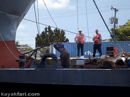
Kayaking today’s Miami River Canal:
Part II
.
Saltwater Tidal Inlet – Industrial and historic route!
.
Story continued from:
Paddling the Miami River Canal – Part I: Engineered Freshwater
.

The salty side of the Miami River Canal is only about 6 miles from Biscayne Bay to the S26 lock.
However in this story we are only covering about half of that!
.
In the previous Miami River story, we covered the roughly 80 miles from Lake Okeechobee down to the S26 lock. Continuing downstream, in this second part of paddling on the Miami River Canal, we are going to explore the stretch from the S26 lock to the Dolphin Expressway overpass. Depending on how much freshwater is being released by the lock, the water in this segment of the river/canal is either brackish or regular saltwater. This is because today’s Miami River effectively functions as a tidal inlet which also winds through densely populated downtown Miami and then opens up to Biscayne Bay on the Atlantic Ocean. Tidal influence this far up the river is usually not a big concern for paddlers unless the SFWMD is releasing a lot of water from Lake Okeechobee!
.
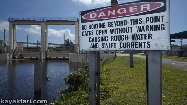
S26 control structure from the freshwater side – CLICK for story!
Paddling the Miami River Canal – Part I: Engineered Freshwater.
.

The the S-26 control structure is a dam that separates the fresh water from Lake Okeechobee and the salt water of Biscayne Bay.
.
.
The S26 structure literally marks the dividing line between the freshwater of the Miami River Canal and the brackish-salty water tidal inlet of the Miami River that runs out to Biscayne Bay.
.

Salty side of the S26 barrier – this will likely be the end of the trip or turnaround point for most paddlers on the Miami River Canal.
Escorting the Betty K VIII out the Miami River and into Biscayne Bay!
.
Following the water,
the Miami River journey continues!
.
We are going to ride out the tide from the S26 dam next to Miami International Airport out to under the Dolphin Expressway overpass. The story is presented this way to allow the reader to go with the flow and follow the water on it’s journey out to the sea. For launching information scroll down through the story.
Please note that there is NO public access to launch or put in a boat at the S26 lock!
.
Along the way, we will paddle through a very industrial section full of recycling plants, salvage yards and shipping docks with large freighter ships. This part is sometimes referred to as “Miami’s Grand Canyon” and was made infamous in the 1980’s Miami Vice TV series. Just past all this, the Miami Canal starts to return more to it’s original Miami River character and route, and we can reminisce a bit about the original river as it once flowed out of the virgin Everglades. There are some interesting historical landmarks as well as remnants of the north and south forks which once fed the original Miami River!
.
.

If you ever want to experience the loudest thing you’ll hear outdoors, just hang out under the tracks! 😉
.

Despite the industrial feel and noise of this area there is still some wildlife to be seen. Shown here is a friendly Yellow-crowned Night-Heron!
.
Unlike the long freshwater segment of the Miami River, the salty side is a busy working commercial waterway. This means that there can sometimes be lots of river boat traffic and ships – very large ships! These ships often thread their way up and down the river with the aid of two tugs. These ships may not be moving fast, but they have a lot of inertia and thus can not stop.
Similar to a freight train, it’s best to stay clear and give wide berth!!
.
.

The “Grand Canyon” on the Miami River – paddling through canyons of ships.
River of Grass Canoe Expedition 2014 – Miami River Canal out to Biscayne Bay!
.
.

Containers await shipping at the docks on the Miami River Canal.
ART of the Miami River – Perspectives of water and people on the move!
.
.
CAUTION:
The Miami River Canal is a working commercial waterway. Always be aware of your surroundings and be prepared to give right of way!
.

Hard working tugs guide and thread giant freighter ships on the Miami River.
Escorting the Betty K VIII out the Miami River and into Biscayne Bay!
.

Dry dock workers at Jones Boat Yard which has been on the Miami River since 1917!
.
.

Ocean going freighters docked on either side leave a very narrow corridor through which to thread the ships through, but local paddler Chelsea K. has found enough room! 😉
.
.

That’s one way to get on board a ship! 😉
ART of the Miami River – Perspectives of water and people on the move!
.

Canoeing past a giant freighter ship. Peace!
River of Grass Canoe Expedition 2014 – Miami River Canal out to Biscayne Bay!
.

One of the dock “anchors” along the Miami River Canal!
Escorting the Betty K VIII out the Miami River and into Biscayne Bay!
.
.

Ships packed with old pickup trucks, SUVs, mattresses and bicycles getting ready to set sail to the Caribbean islands.
River of Grass Canoe Expedition 2014 – Miami River Canal out to Biscayne Bay!
.
.

A yacht all wrapped up in a shipyard on the Miami River.
ART of the Miami River – Perspectives of water and people on the move!
.

Kayaking the industrial Miami River zone at night!
Kayak Miami: Full moon paddling on the historic Miami River!
.

Paddling through an eerie industrial darkness on the Miami River.
Kayak Miami: Full moon paddling on the historic Miami River!
.

Blackness punctuated with blinding spot lights, industrial noises, smells and a lung full of diesel.
Kayak Miami: Full moon paddling on the historic Miami River!
.
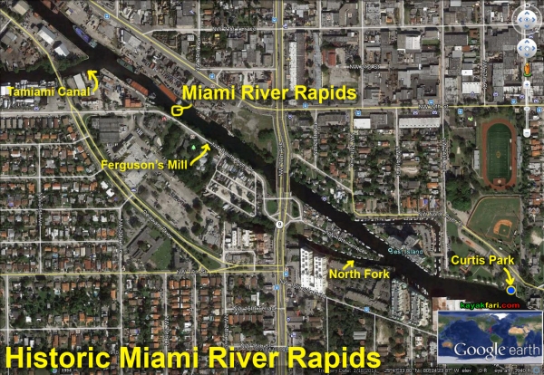
Detail of approximate location of the rapids on the original Miami River.
The falls were dynamited in 1909 and the river bed dredged for drainage and to accommodate ships.
.
Near the south end of the industrial zone is the intersect of the Tamiami Canal which runs out to the Everglades and parallels the Tamiami Trail. Between this point and NW 27th Avenue is where there were once waterfalls on the original Miami River.
Back in 1849 in it’s natural state, the U.S. Coast Survey reported that “from the upper falls to near its entrance into Key Biscayne Bay… water in the Glades was 6 feet 2.5 inches (1.892 m) above low tide.”. The eastern edge of the Everglades was just a couple of miles away!
There is no evidence of anything left today, save for one culvert which once lead into Ferguson’s Mill – the largest commercial site in Dade County prior to the Civil War.
.
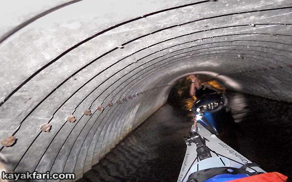
Inside the culvert that once lead to historic Ferguson’s Mill. It is a dead-end today and unfortunately culverts like this act like conveyors that deposit a lot of trash into Biscayne Bay!
CLICK for story: All that trash – the ugly side of kayaking in Miami.
.
.

Water running out of the Everglades over rapids on the Miami River just before they were dynamited!
Credit R.S. Smith (1909) / U.S. Geological Survey and History Miami Archives and Research Center.
.

There are lots of green iguanas living everywhere along the river. This is a fine 5 foot specimen along one of the bridges.
.
.
Just past today’s NW 27th Avenue across from Jest Isle once flowed the North Fork of the Miami River. Today this is a dead-end under the road, but there were once Tequesta settlements there!
.
.
Curtis Park on the north bank of the Miami River is the best place to launch into the river to explore this segment. It’s located roughly half way between the S26 lock and the Dolphin Expressway overpass. Launching here is easy with plenty of parking space, however you may come across lots of trash and possibly remains of Santería sacrifices sometimes.
.

‘Indian Head’ at the old Curtis Park boat ramp on the Miami River canal.
Spooky night time paddling and filming on the Miami River with ARTE (Euro TV)!
.

Most likely a Santería sacrificial offering found at Curtis Park.
.
.

The new boat ramps at Curtis Park are open and look almost the same as before. I’m not really sure what took two years to accomplish here except for the freshly paved parking lot?
.
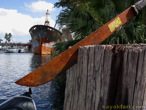
“Welcome to Miami!”
Rusty machete with the rusting hulk of the Borocho in the background.
.
CAUTION:
The Miami River Canal is a working commercial waterway. Always be aware of your surroundings and be prepared to give right of way!
.
.
Flowing downstream, just past the South Fork of the Miami River is Sewell Park with it’s large Royal Palms lining the river bank on the south side. Named after E. G. Sewell, a former Mayor of Miami, this is a beautiful park with lots of space and even it’s own canoe launch area. However be aware that the canoe ramp is very slippery with algae and kind of broken up. Also, the parking is very limited and the carry to said canoe area is quite long, so it’s not the best place to launch. It does however make an excellent stop over or lunch spot!
.

The large freighter “Miami Super” snakes around the bend at Sewell Park.
River of Grass Canoe Expedition 2014: Lake Okeechobee – Miami River Canal – Biscayne Bay
.

Aerial view of the canoe launch at Sewell Park on the Miami River.
River of Grass Canoe Expedition 2014 – Miami River Canal out to Biscayne Bay!
.
Sewell Park is bordered by NW 17th Avenue on the east side and there is a tiny creek there called the Lawrence Canal which leads south. It was cut through the limestone rock in the 1920’s, and is yet another dead-end (very close to the Marlins Stadium). However situated just a little ways in is the Miccosukee Tribal Embassy which is a sacred and historical site and sits atop of the Miccosukee Miami “Caves”. These aren’t real caves but are believed to have originated as natural solution holes in the soft limestone rock. They were later enlarged and today sometimes house native dugout canoes. They are not open to the public, but are fun to check out from the water!
.
.

Paddling past the Miccosukee Embassy on the Miami River at night.
Kayak Miami: Full moon paddling on the historic Miami River!
.

Seminole native peoples in dugout canoes on the Miami River in 1916.
Credit: State Archives of Florida, floridamemory.com
.

“Miccosukee cave dugout canoes”
At the ‘Miccosukee Miami Caves’ – Miccosukee Embassy on the Miami River.
ART of the Miami River – Perspectives of water and people on the move!
.
.

Sadly there is always a lot of trash on the Miami River, however this is one of the more interesting pieces!
CLICK for story: All that trash – the ugly side of kayaking in Miami.
.
.
Read more about Miami’s history in this excellent book:
Along the Miami River by Paul S. George.
.

NW 17th Avenue across the Miami River marks the eastern boundary of Sewell Park and the tiny Lawrence Canal.
.
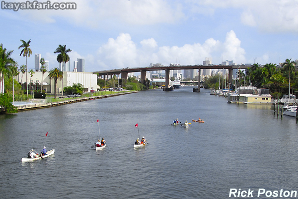
Canoe expedition team paddling with the water out towards the Dolphin Expressway overpass!
River of Grass Canoe Expedition 2014 – Miami River Canal out to Biscayne Bay!
.
(* Due to construction, the access under the expressway is fenced off as of June 2019 *)
Under the Dolphin Expressway overpass is the third option for launching on the Miami River. This is right in front of the big courthouse and there is plenty of metered street parking. It is an unofficial launch area with a gentle grassy slope like a boat ramp and is separated from the main river channel. Be sure to pay attention if you launch here because it’s in a constricted area of the river and the ships are not expecting to see paddlers!
.
The best place to launch to access this part of the Miami River is still at the Curtis Park boat ramp!
.
CAUTION:
The Miami River Canal is a working commercial waterway. Always be aware of your surroundings and be prepared to give right of way!
.

It is possible to launch directly under the Dolphin Expressway and pay park on the street. NOTE: Access fenced off as of June 2019!
.
Excellent documentary on the Miami River by Academy Award® nominated filmmaker Katja Esson:
“Miami River- Crocodiles and Cruise Ships”
https://vimeo.com/184833828
.
.
Continue on to
Miami River Canal – Part III – Salt water route to Biscayne Bay!
(** Coming soon **)
.
Enjoy!
.
.
Related content you may also like:
.
.
.
.
.
.
.
.

.
.
© 2018 – 2021 Flex Maslan / kayakfari.com / awakenthegrass.com. All original photographs, artworks and music in this portfolio are copyrighted and owned by the artist, Flex Maslan, unless otherwise noted. Any reproduction, modification, publication, transmission, transfer, or exploitation of any of the content, for personal or commercial use, whether in whole or in part, without written permission from the artist is strictly prohibited.
All rights reserved!
…
DISCLAIMER:: The maps and images on this site are not intended for navigation, I am not a guide; use any and all information at your own risk! Your mileage may vary .. so use good judgement before venturing out!
With that said..
Blessings friends!
![]()


