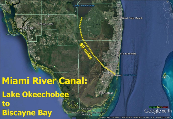
Part I – Paddling the engineered freshwater flow.
.
To start, we are going to go up all the way to Lake Okeechobee
and flow downstream with the water!
.
.
Paddling and exploring the Miami River Canal!
In this two part series on paddling the Miami River Canal, we are going to explore a bit about the Everglades, a little history of South Florida and the possibilities of some interesting and off-beat paddling and sights. The entire canal runs for about 80 miles from Lake Okeechobee out to Biscayne Bay and can be divided into two major segments. The first and longest is the freshwater stretch that runs mostly through unpopulated Water Conservation Areas of the Everglades. The second is a much shorter brackish and saltwater tidal inlet which winds through densely populated downtown Miami and is open to the Atlantic Ocean.
.

Paddling along the southern perimeter of Lake Okeechobee bounded by the Hoover Dike berm.
.
Why paddle these largely unknown and possibly
unloved parts of South Florida on this canal?
Well it’s a chance to experience firsthand the flow of the water in today’s re-plumbed Everglades ecosystem. Additionally, it’s kind of neat to paddle into the city from outside and see the transitions and many changes made within the last one hundred years.
It’s also a chance to get a new and wider perspective of the big picture of the Everglades and of South Florida that many people only read about but may not really comprehend!
.

Canoeist on Lake Okeechobee with sugar cane fields burning in the background. This has been standard harvesting practice for decades but has become controversial as the smoke impacts the ever growing South Florida population.
ART of the Miami River – Perspectives of water and people on the move.
.
Historically the Miami River was a fairly short natural artery that drained freshwater out of the Everglades into Biscayne Bay via two forks. About one hundred years ago, in the early 20th century major efforts to drain and “reclaim” the Everglades started in earnest. This resulted in the construction of four major canals that drained freshwater from Lake Okeechobee for agricultural and urban needs. One of these called the C-6 Canal, is also called the Miami Canal and is one of the many components of the very extensive SFWMD system of canals, levees and pumps. This canal eventually connects to what is left of the original Miami River in downtown Miami today.
.

Pump station S-3 is the “headwaters” of the Miami River Canal. This structure controls all the water that will end up in the Miami River & Canal!
.
Pictured above is the S-3 control structure on south rim of Lake Okeechobee, which is the “source” of the Miami River today. The canal, along with the Hoover Dike and a handful of other drainage canals is what allows for the huge downstream Everglades Agricultural Area (EAA) to exist. For decades the EAA has been agriculturally and economically very productive, but it has also been the source of ongoing environmental problems for the Everglades and all of South Florida in general. Re-plumbing the complex system of canals and levees in South Florida is a major part of Comprehensive Everglades Restoration Plan unfolding right now!
.
.
From these “engineered headwaters” the Miami Canal then runs for about 55 miles south east until it intersects with the L-67A levee/canal. Paralleling this long canal are the other canals dug at about the same time in the 1920’s. If you’d like to see what that’s like, check out the 2012 River of Grass Canoe Expedition, which followed the water flow in these canals down to the Tamiami Trail. Be sure to also watch the excellent and informative video that was produced as part of an educational outreach and awareness effort for local South Florida grade schools!
.

The more interesting paddling segment on the Miami Canal is from Mack’s Fish Camp up to the intersect with L-67A.
.
Much of the information gathered and presented in this story is from the
River of Grass Canoe Expedition 2014
which followed the water from Lake Okeechobee out to Biscayne Bay via the Miami River Canal!
.

Tourist airboats at Holiday Park on the L-67A canal which intersects the Miami Canal. This could be another optional launch point for paddlers seeking a longer canal paddling route.
.

Paddling on a seemingly endless canal cutting through Water Conservation Area 3.
.
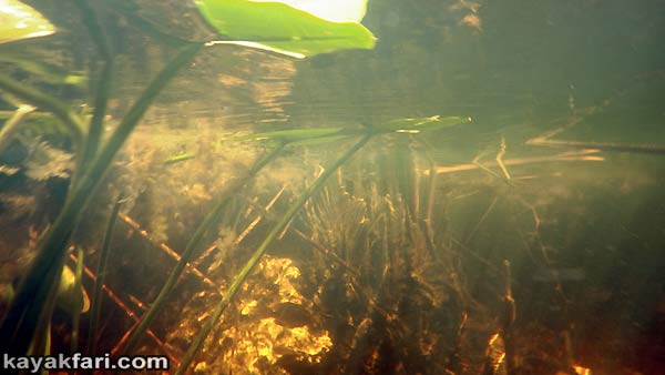
Underwater view of the Miami Canal. Note the limestone rock, which continues to be quarried in prodigious quantities downstream along this same canal.
.
Most kayakers would find paddling the entire Miami Canal to be a very monotonous and linear experience, not to mention far too long. The exception could be those looking for marathon distance training perhaps. To get a taste of this kind of paddling in a much shorter and doable format, I’d suggest going a little further south along the Miami Canal to where it intersects another canal. This is the L-67A, which also marks the boundary of WCA-3B. On this short stretch, quite a bit of bird life can be seen depending on the season!
.
.

On this stretch of the Miami Canal quite a bit of bird life can be seen, such as these beautiful Roseate Spoonbills.
CLICK for page: The Everglades are for the birds!
.
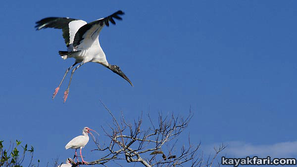
A Wood Stork (“Ironhead”) lifts off. There are also lots of Ibis, Anhiga and some Cormorants!
CLICK for page: The Everglades are for the birds!
.
About 5 miles from the intersection with L-67A lies a Shangri-la of sorts called Mack’s Fish Camp. It’s like a small oasis on the very edge of the sea of suburban sprawl and development. Mack’s has a real old time Florida feel to it and it’s origins go back to a squatter’s camp in the early days of life on the canal. Today it is the last of it’s kind in South Florida! It’s quiet, save for some distant noises from airplanes en route in and out Miami International Airport (MIA). If you want to paddle this part of the Miami River Canal, this is a clean and secure place to launch from. It is accessible via a dirt road just a couple of miles from Hwy 27 off Krome Avenue (997) in far western Miami-Dade county.
.

The tiny hamlet that is Mack’s Fish Camp on the edge of civilization. It’s a great place to launch for paddling this stretch of the Miami River Canal.
.
.
.

“Metal Jaws of Gator” – a sculpture at Mack’s Fish Camp on the Miami River Canal.
ART of the Miami River – Perspectives of water and people on the move.
.

Nice dreams camping along the Miami River Canal at Mack’s Fish Camp with Orion overhead.
CLICK for story: ART of Darkness – Camping with the Stars! Part II
.

From Mack’s, it is 22 miles out to the sea! However there are two portages marked in red. The freshwater segment ends at the S26 Water Control Structure near MIA.
Blue marks the access points to the Miami River Canal.
.
Once out of the water conservation area, the Miami Canal runs through several miles of what looks like a DMZ. There are seemingly endless acres of huge artificial lakes, rock quarries and vacant land. There is no wildlife nor any fish. The vegetation consists mostly of opportunistic invasive species such as the Melaleuca forests and large patches of Australian Pines. Along the canal banks, shrubs of Brazilian pepper and underwater mats of Hydrilla are found everywhere. The background soundtrack is a kind of ambient-industrial mix of pounding, scraping and various machine and exhaust noises. It’s quite a contrast to the Everglades!
.
.
If you want to see a destroyed Everglades ecosystem,
this is the place!
.
.

Paddling past fresh made Churros sold out of the back of the old van where the Florida’s Turnpike intersects Okeechobee Rd. on the Miami River Canal.
.
Paddling this stretch of the Miami River Canal is a chance to get
a new and better view of the big picture of life in South Florida!
.
.
Where the Miami Canal intersects Florida’s Turnpike pretty much marks the boundary of the Miami suburban metropolis as we know it. From this point on, it is all city paddling. Along with entry into the city however also come ever increasing amounts of trash. Trash of many types, but mostly the usual culprits of plastic bottles, beer cans, cigarette butts and foam cups and food containers. Some of this is careless littering, but a lot of trash simply gets wind blown into the canal and into the street sewers that ultimately feed into it. In certain parts aging trash literally lines the banks of the canal!
.

Trash and algae line the banks of the Miami River Canal.
CLICK for story: All that trash – the ugly side of kayaking in Miami!
.

Picking up trashed mylar balloons clogging up the Miami River.
CLICK for story: All that trash – the ugly side of kayaking in Miami!
.
Okeechobee Rd parallels the Miami Canal on the east side along the entire freshwater segment all the way down to the airport. The sights and sounds are pretty much the same as if you were riding around on a bicycle. The difference is that you can’t get run over on the canal because only kayaks, canoes and small skiffs can fit under the many low bridges!
.

One of the side benefits of paddling in the city is the possibility to jump out and get some fresh Cafe Cubano!
.

There is but one little boat ramp on the upper section of the Miami River Canal in Medley. It’s a good central location, particularly for going south to the S26 salt water lock.
However, be sure to inquire locally before making plans to launch there!
.
Truth is that one can put in almost anywhere into the canal, as long as there’s an embankment and nearby safe parking. However actual boat ramps or any launch spots are non-existent except for one. There is a little boat ramp in an industrial warehouse section of Medley on the west side. Adjacent to it there’s plenty of parking room, but all posted as tow-away zones and the gate looks locked. So it would be a good idea to ask around at the businesses next door before making plans to launch from there! I include it because it is definitely a possibility that you should investigate if you really want to paddle this stretch.
.

Small boat ramp access to the Miami River Canal in an industrial section of Medley.
It’s on NW South River Dr, between NW 106th and NW 109th Streets.
Photo credit: GoogleEarth – CLICK for street view.
.
.
.
.
Just past the intersection of the Miami River Canal and the Palmetto Expressway, the landscape changes yet again. In contrast to the working and industrial feel of Medley, this section flows through lush, green and very suburban Miami Springs to the southwest. On the east side are neighborhoods of Hialeah, although they are harder to see due to traffic on Okeechobee Rd.
.
.
.

This picture explains why you won’t see any powerboats other that small skiffs – the overhead clearance is too low!
.
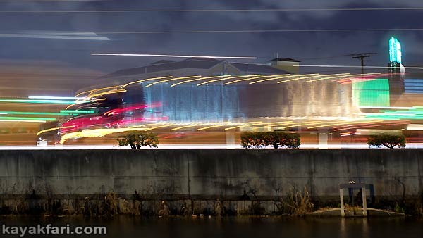
“Truckin’ in the still of the Night”
Tractor trailer truck rambles along Okeechobee Road into the night.
ART of the Miami River – Perspectives of water and people on the move.
.

Bright lights along Okeechobee Road which was built from the fill dredged to make the canal!
ART of the Miami River – Perspectives of water and people on the move.
.
Paddling this section presents an interesting mix of sights and sounds. There’s the constant traffic on Okeechobee Rd on the east side and everyday life going on along the western edge of the canal. People jogging, walking their dogs, some land fishermen and lots of people’s back yards. Seeing it all from the water makes for a different kind of experience. It’s true that wherever there’s water, it exerts a calming influence. The Miami River Canal is no exception and it is another kind of waterfront living in Miami!
.
.
.
.
.

The Miami River passes right along the edge of Miami International Airport.
This is a very noisy place to be on the river!
.
Once past the Miami International Airport (MIA) is the S26 Water Control Structure. It’s right under the very busy interchange of Airport Expressway (112), Okeechobee Road, US 27, LeJeune Rd and NW 36 Street, where airplanes scream and climb sharply into the blue sky yonder while Miami motorists scoot around in all directions!
The structure also literally marks the dividing line between the
freshwater of the Miami River Canal and the brackish-salty water
tidal inlet of the Miami River that runs out to Biscayne Bay.
The S26 barrier signifies the end or turn around point for most paddlers whether on the fresh or salty side. While a portage is technically possible and has been done, the area is fenced in and locked. It’s also surrounded by private property, further complicating things. I would not recommend doing this portage without local contacts and knowledge!
It’s hardly a showstopper though, particularly for paddlers coming up to this point from Biscayne Bay. As we shall see in the second and third parts of this series, it makes a great turn around point anyway.
.
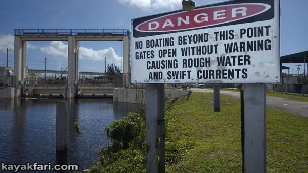
This is the S-26 control structure that separates the fresh water from Lake Okeechobee and the salt water of Biscayne Bay.
.
Flowing with the water from the Everglades into the city on the freshwater canal segment of the Miami River may not be for everyone and the paddling might sometimes not seem very glamorous.
However, it is nevertheless a real genuine Miami experience!
I hope you’ve enjoyed this little tour of the seldom seen
freshwater part of the Miami (River) Canal!
.

The S26 barrier will likely be the end of the trip or turnaround point for most paddlers on the Miami River Canal.
Portage is possible but hampered by fences, locked gates and private property!
.
.
Continue to Part II:
Paddling the Miami River Canal – Part II:
Industrial and Historic Route!
.
.
.

.
.
© 2016 – 2022 Flex Maslan / kayakfari.com / awakenthegrass.com. All original photographs, artworks and music in this portfolio are copyrighted and owned by the artist, Flex Maslan, unless otherwise noted. Any reproduction, modification, publication, transmission, transfer, or exploitation of any of the content, for personal or commercial use, whether in whole or in part, without written permission from the artist is strictly prohibited.
All rights reserved!
…
DISCLAIMER:
The maps and images on this site are not intended for navigation, I am not a guide; use any and all information at your own risk! Your mileage may vary .. so use good judgement before venturing out!
…
I hereby disclaim any sponsorship, endorsement, nor association with any product or service described herein. The photographs, depictions, products, and ideas presented on this site are for informational purposes only. Your results may vary, and I do not imply nor guarantee the effectiveness, suitability, design or operation to adhere to any standard. I assume no legal responsibility for the implementation of anything herein presented! Use any and all information at your own risk! By using any and all information from this website, you accept the final liability for any use or possible associated misuse!
.
With that said..
Blessings friends!
![]()

